Revegetation Plan – Potential Mitigation Sites
Revegetation Plan continued:
Six sites in the Laws wellfield were identified in the EIR as candidates for “selective mitigation” that would not interfere with water management activities and would require approval from the Inyo/Los Angeles Standing Committee. Past, and in some cases, current impacts to these sites include a combination of groundwater pumping, abandoned agriculture, water spreading, fires, and “other factors.”
Another group of four sites were slated to be mitigated by re-greening projects (three sites) or converted to alfalfa (E. Shepherd Creek). However, at the East Big Pine site, if re-greening is deemed infeasible, then the secondary goal is to revegetate with native plants. These four sites are addressed in this plan as potential mitigation sites if circumstances lead to a change in the mitigation goal.
Because of the potential nature of these sites, they were not addressed as thoroughly as those in the previous sections. Half of the six sites in the Laws wellfield are low priority because the existing vegetation cover appears to keep wind erosion and weed invasion low. The other three show signs of wind erosion and will be addressed after mitigation has begun on high priority ABAG and groundwater impacted sites. Site goals are only qualitative and boundaries were not delineated from field visits; maps presented in this report are from the EIR. Also, the E/M sites were not given a priority designation or species list.
| Impact # | Site Location | Acres |
| 10-18 | Laws 33 | 93 |
| Laws 36 | 99 | |
| Laws 88 | 136 | |
| Laws 82 | 36 | |
| Jean Blanc Rd. | 258 | |
| Laws return ditch (124) | 62 | |
| 10-19 | Northeast Big Pine | 30* |
| 10-19 | East Big Pine | 20* |
| 10-11 | E. Independence | 30* |
| 10-11 | E. Shepherd Creek | 60* |
* denotes acreage given in the EIR
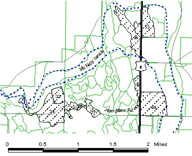
Revegetation Plan Figure 8
Laws Sites
There are six distinct Laws sites, the first four are named by their vegetation parcel number and are easily accessed from Hwy. 6 (See Figure 8.) All the sites, with the exception of a portion of the Jean Blanc Rd. site are located on the Laws USGS 7.5’ quad.
This site was mapped by LADWP as a 93 acre Nevada Saltbush Scrub, parcel no. 33 (T6S R33E, NW1/4NW1/4 and SW1/4NW1/4, Sec. 23) with 19% live cover. However, 50% of the plant composition consisted of Russian thistle and fivehook bassia, 45% and 5% respectively. The site can be accessed from a canal road off Hwy. 6. The site has sparse to dense native vegetation scattered throughout the parcel but there are areas that remain barren. Revegetation efforts will be limited to identifiable barren areas.
This site is split between two soil map units, a complex of Sabies (fine-loamy, mixed (calcareous), thermic Xeric Torriorthents) and Yaney (coarse-loamy, ashy (calcareous), thermic Vitrandic Torrifluvents) soils and an association of Yaney and Yaney soils. (The two Yaney soils vary in surface textures, one is sandy and the other is loamy.) All have moderate to moderately rapid water permeability, high available water capacity, and moderate (Sabies-Yaney) or severe (Yaney-Yaney) wind erosion. Limiting off-road vehicles and careful grazing management to preserve plant cover and prevent soil erosion were recommended for both soil units.
The high cover of weedy species and grazing are constraints to revegetating the site.
Goal: Assist expansion of native plant species that already exist on the site onto barren areas .
Priority: Low – Wind erosion doesn’t appear to be a problem at this site. There is also an adequate seed source on site. This site is slated for protection in 2001 if approved by the Standing Committee, however, unresolved litigation may complicate revegetation plans.
Revegetation plan:
Eliminate disturbances
Site protection will be the main revegetation activity until monitoring indicates the need for further action.
Monitor
If protection produces no apparent positive changes then additional plans will include weed control, protecting natural recruitment if helpful in other areas, and possibly planting or seeding native plants.
Species list for Laws 33, 36, 88, and 82 sites:
This list for seed mixes and container plants includes species from the following plant communities: Great Basin Mixed Scrub, Shadscale Scrub, Desert Sink Scrub, Rabbitbrush Scrub, Rabbitbrush Meadow, Nevada Saltbush Scrub, and Desert Greasewood Scrub.
Shrubs/Forbs:
allscale saltbush1b
indigo bush1b
Nevada ephedra1b
black greasewood1b
little horsebush1b
Parry saltbush1b
bud sagebrush1b
longspine horsebush1b
shadscale1b
desert alysum1b
Nevada dalea1b
Grasses:
alkali sacaton1b
Indian ricegrass2
saltgrass1b
This site was mapped as parcel no. 36 (T6S R33E, NE1/4 and SE1/4 Sec. 9), 99 acres of Desert Sink Scrub with 19% live cover, 58% of the cover is Russian thistle. This site is accessible from Hwy. 6. Much of the area is used for surface water spreading, and in anticipation of water spreading in 1993, the soil was ripped, although no water was spread on the site.
The soil at this site was mapped as a Yaney-Yaney association that was described in the previous description, Laws 33.
Currently, there is perennial native vegetation between the ripped areas which could provide a seed source but occasional ripping as well as wind erosion is likely a serious obstacle to recruitment.
Goal: Develop a procedure that allows for continued surface water spreading without leaving barren ground. This procedure needs to accommodate both spreading and non-spreading years as in 1993, when high runoff is anticipated but ripped areas are not subsequently wetted.
Priority: High – This site has high wind erosion when ripped and not wetted. This site is slated for fencing in 2000 if approved by the Standing Committee, however, unresolved litigation may change revegetation plans.
Revegetation plan:
Remove disturbances on water spreading areas
Fence water spreading areas to keep soil erosion to a minimum and potentially allow vegetation to cover the soil after water is evaporated.
Seed
Develop a mix of plants species to be spread on ripped soil both during spreading and after water has begun to evaporate. Initially no additional irrigation will be used.
Monitor
This site will be carefully monitored for the presence of tamarisk and perennial pepperweed. If these weed species are found, weed control will be implemented immediately.
This area was mapped as parcel no. 88 (T6S R33E, SW1/4, Sec. 15), 136 acres of Desert Sink Scrub with 14% live cover. Russian thistle was the dominant species and tamarisk composed 1% of the plant cover. Approximately 1/3 of the parcel has been leveled for agriculture, but the remaining section has retained a natural topography. Some of the shrubs and grasses near the northern border receive tailwater from irrigation. Two irrigation canals on the site have cottonwoods and willows growing on the edges. Natural recruitment of native grasses and shrubs is occurring. Weeds include Russian thistle, tamarisk, annual Atriplex, and fivehook bassia. Much of the site has an acceptable cover of vegetation, although there are spots that remain barren. Revegetation efforts should assist natural recruitment and only be necessary in the barren areas.
The soil at this site was mapped as a Sabies-Yaney complex that was described in the previous description, Laws 33.
Goal, Priority, Revegetation plan and Species list: Same as Laws 33 with the addition of:
Conduct more site specific soil characterization.
On-site soil characterization and/or fertility tests will be conducted
because of mineral toxicity reported by lessee.
This site was mapped as parcel no. 82 (T6S R33E, SE1/4NE1/4, Sec. 16), 36 acres of Rabbitbrush Meadow with 18% live cover. Russian thistle made up 13% of the plant composition when mapped. The site has many shrub islands between barren areas and the vegetation parcel boundaries are indistinct on the ground. Although the site has not been leveled, historically the area was disturbed by tracks for the narrow gauge railroad which is still visible on aerial photos.
The soil at this site was mapped as a Sabies-Yaney complex that was described in the previous description, Laws 33.
On-going disturbances include heavy equipment, wind erosion, groundwater pumping, and grazing. Extending west beyond this mapped site into parcel 81, there are similar barren areas which could also benefit from rehabilitation.
Goal, Priority, Revegetation plan, and Species list: Same as Laws 33
This site contains areas impacted by both abandoned agriculture and groundwater pumping (See Figure 8.) Parcels in this area include – on the Laws 7.5’ USGS quad: vegetation parcel no. 75 (T6S R33E, SW1/4SE1/4, Sec. 17), mapped as 30 acres of ABAG; no. 76 (T6S R33E, SE1/4SE1/4 Sec. 17), 10 acres of 7% live cover of Desert Greasewood Scrub; and no. 77 (T6S R33E, SW1/4SW1/4, Sec. 16), 31 acres of ABAG. The Fish Slough quad includes vegetation parcel no. 34 (T6S R33E, SW1/4, Sec. 17, NW1/4 Sec. 20), with 153 acres of ABAG and parcel 33 (T6S R33E, NE1/4SW1/4 Sec. 17), 34 acres that were formerly the Laws treelot.
The impacts at these vegetation parcels appear to have been exacerbated by drought, groundwater pumping, and grazing. A nearby exclosure demonstrates higher plant cover and mulch inside the fenced plot compared to surrounding areas.
Soils were mapped as a complex of Goodale (sandy-skeletal, mixed, thermic Xeric Torriorthents) and Yaney (coarse-loamy, ashy (calcareous), thermic Vitrandic Torrifluvent) soils. Sixty five percent of the map unit is composed of Goodale soils and similar inclusions and 20% is Yaney soils and similar inclusions. Although both soils have moderately rapid to moderate permeability and high salinity and sodicity, they differ in available water capacity and hazard of wind erosion. The Goodale soils have low available water capacity and severe hazard of wind erosion, in contrast to the Yaney soils with high available water capacity and slight wind erosion hazard. Management recommendations include limiting off-road vehicles and careful grazing management.
Goal: Revegetate the site with plant species found on site and in the
surrounding areas.
Priority: High – This site will require several years of experimentation to develop effective techniques because of its large size and saline soils. It is anticipated that this site will be fenced in 2000 if approved by the Standing Committee.
Revegetation plan:
Eliminate disturbances.
Fencing will be critical to revegetation success and should be constructed as soon as feasible.
Conduct more site specific soil characterization
On-site soil characterization and fertility tests will be conducted if they have proven useful at other sites.
Use container plants in test plots
Plant protectors or mulch will be used to protect transplants.
Use mulch
Mulch will be spread in rows to catch soil, seeds, and litter and to protect transplants.
Seed
A variety of species will be seeded in the autumn using the drill seeder if successful at previous revegetation sites. Mulch may be used to spread over the seeded area to reduce wind erosion.
Site maintenance
Monitor
If seeding and transplants fail, soil inoculation and/or soil amendments will be tested.
Species list:
This species list for seed mixes and container plants includes species from the following plant communities: Alkali Meadow, Rabbitbrush Meadow, Nevada Saltbush Meadow, Rabbitbrush Scrub, Nevada Saltbush Scrub, Desert Sink Scrub, Shadscale Scrub, and Desert Greasewood Scrub.
Shrubs/Forbs:
allscale saltbush1b
inkweed1b
shadscale1b
black greasewood1b
Nevada dalea1b
shrubby alkali aster1b
fourwing saltbush1b
Parry saltbush1b
Grasses/Grasslike:
alkali muhly
beardless wildrye1b
Great Basin wildrye1b
alkali sacaton1b
carex1b
saltgrass1b
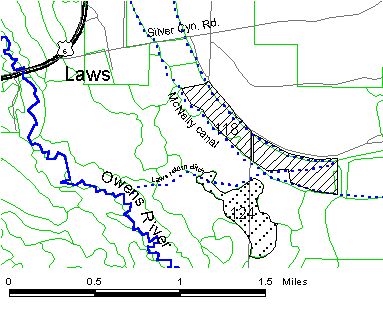
Revegetation Plan Figure 1
Laws Site
This site is in vegetation parcel no 124 on the Laws 7.5’USGS quad (T6S R33E, NW1/4NW1/4 Sec. 35 & NE1/4NE1/4 Sec. 34), mapped as 62 acres of ABAG (See Figure 1.). It is accessible from the Laws-Poleta Rd. The site topography varies between areas with hummocks and areas that have been leveled. The vegetation is mainly weedy native and non-native species. Current impediments to recruitment include groundwater pumping and grazing.
The soil at this site was mapped as a Sabies-Yaney complex that was described in the previous description, Laws 33.
Goal: Revegetate the site with species found in surrounding parcels. This site probably had a higher water table supporting plant communities that can no longer be maintained with the current conditions.
Priority: Medium – This site doesn’t appear to have severe wind erosion problems, but because it has weedy species and shows no signs of natural recruitment, it may be a difficult site to revegetate. It is anticipated that this site will be fenced in 2000 if approved by the Standing Committee.
Revegetation plan:
Eliminate disturbances
The site will be fenced.
Test transplants and seeding
Plant container plants in windbreak rows if it has been successful at previous sites. Use the seeding method that has proven the most successful at other mitigation sites.
Site Maintenance
Monitor
If seeding and transplants fail, soil inoculation and/or soil amendments will be tested.
Species list:
The species list for this site is the same as for the Laws Jean Blanc Rd. above with the addition of the following shrubs:
desert alysum1b
longspine horsebush1b
Enhancement/Mitigation projects
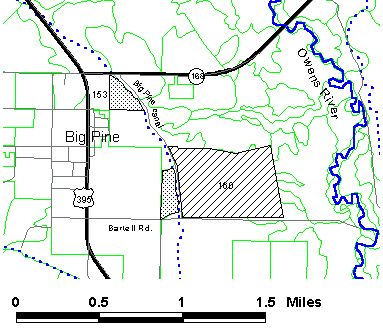
Revegetation Plan Figure 3
Big Pine Site
This site is slated to be a re-greening project described as 30 acres of irrigated pasture (See Figure 3.). The 30 acres are contained within the 167 acre Rabbitbrush Scrub parcel no. 153 on the Big Pine 7.5’ USGS quad (T9S R34E, SE1/4NW1/4 Sec.17). It was planted in alfalfa in 1924 but there are no records of when it was taken out of production (furrows are still visible). Live cover was mapped at 25% with Russian thistle comprising 30%. The EIR delineates only the area with the sparsest cover within the vegetation parcel. Near the Big Pine canal,
vegetation is the most dense with willow, Nevada saltbush, saltgrass and weedy annuals. Current impediments to natural recruitment include off-road vehicle traffic and invasion of weedy plants.
This site spans two soil map units; one is a complex of Hesperia-Cartago soils that was described for the Big Pine ABAG site and the other is a Shondow-drained Hessica, sandy substratum association with 0-2% slopes. The Shondow soils are fine-loamy, mixed, thermic Aquic Argixerolls and the Hessica soils are fine-loamy, mixed, thermic Xerollic Natrargids. This map unit is located in the northern portion of the site. These soils have moderate to moderately slow permeability and high available water capacity. Management considerations include moderate to severe wind erosion hazard and potentially high salinity and sodicity. Off-road vehicles should be limited and grazing should be carefully managed to preserve soil and vegetation cover.
Goal: Revegetate the site with plant species found in the surrounding area. Near the canal, species with higher water requirements could be used.
Revegetation plan:
Eliminate disturbances
The site will need to be fenced, and this would be the initial revegetation method.
Monitor
If recruitment of desirable species is observed, then protection without additional input will be continued. If protection produces no apparent positive changes then additional plans will be developed. These will include weed control, protecting natural recruitment if helpful in other
areas, and possibly planting or seeding native plants.
This 20 acre site (See Figure 3.) was discussed earlier in the Big Pine ABAG section. The revegetation plan for the two sites would be the same.
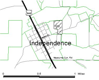
Revegetation Plan Figure 9
East Independence
This 30 acre site is slated as a re-greening project in the EIR (See Figure 9.), however, the site was mapped as 20 acres, parcel no. 188 on the Independence 7.5’ USGS quad (T13S R35E, SE1/4NW1/4 Sec17). It is easily accessible by town roads and adjacent to the Little League
field which contributes to heavy vehicle disturbance. The presence of weedy plant species (fivehook bassia and Russian thistle) are also a potential revegetation problem. Native perennial plant species (fourwing saltbush, saltgrass, and alkali sacaton) are present and recruitment was apparent, although the previously mentioned disturbances will likely prevent site rehabilitation from occurring without intervention. If the site is turned into an irrigated pasture, Los Angeles will be the lead party responsible for implementing the project. But, plans for a native plant site have been developed.
Soil at the site was mapped as Shabbell sandy loam with 0-2% slopes. Shabbell soils are coarse-loamy, mixed thermic Aridic Argixerolls. This soil has moderately rapid permeability and moderate available water capacity. Wind erosion hazard is moderate. Soil management recommendation include revegetating disturbed areas as soon as possible as well as careful grazing management that takes soil temperature and wetness into consideration.
Goal: Rehabilitate the site with native plants similar to communities at the same elevation north and south of town.
Revegetation plan:
Eliminate disturbances
The site will need to be fenced, and this would be the initial revegetation method.
Contact local organizations that may be interested in the project
Volunteers may be willing to volunteer for planting and site maintenance.
Monitor
If recruitment of desirable species is observed, then protection without additional input will be continued. If protection produces no apparent positive changes then additional plans will be developed. These will include weed control, protecting natural recruitment if helpful in other areas, and possibly planting or seeding native plants.
Revegetation Plan Figure 10
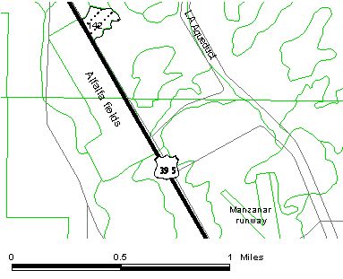
East Shepherd Creek Site
This site was described in the EIR as 60 acres that are “poorly vegetated.” The area is easily accessible from Hwy. 395 . The northern portion of the impact site was mapped as vegetation parcel 142 (See Figure 10.) on the Independence 7.5’ USGS quad (T13S R35E, NW1/4SW1/4 Sec. 34). Parcel 142 is described as having 18 acres of Nevada Saltbush Scrub with 80% live cover. This cover, when mapped was composed of 75% Russian thistle, 21% fivehook bassia, and 1% Nevada saltbush. If perennial vegetation does not naturally increase, it is planned to become an expansion of the E/M alfalfa field on the west side of the highway. If the site is turned into an alfalfa field, Los Angeles will be the lead party responsible for implementing the project.
Soil at the site was mapped as complex of Morey family-Winnedumah, drained-Rindge family with 0-2% slopes that was described for the Independence sites.
Goals: Revegetate the site with plant species found in the surrounding area on the same soil type.
Revegetation plan:
Eliminate disturbances
The site will need to be fenced, and this would be the initial revegetation method.
Monitor
If recruitment of desirable species is observed, then protection without additional input will be continued. If protection produces no apparent positive changes then additional plans will be developed. These will include weed control, protecting natural recruitment if helpful in other areas, and possibly planting or seeding native plants.