MOU
MEMORANDUM OF UNDERSTANDING BETWEEN THE
CITY OF LOS ANGELES DEPARTMENT OF WATER AND POWER,
THE COUNTY OF INYO,
THE CALIFORNIA DEPARTMENT OF FISH AND GAME,
THE CALIFORNIA STATE LANDS COMMISSION,
THE SIERRA CLUB, THE OWENS VALLEY COMMITTEE,
AND CARLA SCHEIDLINGER
TABLE OF CONTENTS
SECTION I – GENERAL PROVISIONS
A. PARTIES B. INTRODUCTION C. INYO COUNTY-LOS ANGELES LONG TERM WATER AGREEMENT D. DEFINITIONS
SECTION II – LOWER OWENS RIVER PROJECTA. LORP PLAN B. GOAL OF THE LORP C. PHYSICAL ENVIRONMENTAL FEATURES D. AGENCY CONSULTATION AND PUBLIC INVOLVEMENT E. MONITORING AND REPORTING PLAN – ADAPTIVE MANAGEMENT F. LORP EIR G. PUMPBACK SYSTEM H. IMPLEMENTATION I. PERMITS, APPROVALS, LICENSES
SECTION III – ADDITIONAL COMMITMENTSA. STUDIES, EVALUATIONS AND COMMITMENTS 1. Yellow-billed Cuckoo Habitat
2. Inventory of Plants and Animals at Springs and Seeps (LORP Planning Area)
3. Additional Mitigation
B. OWENS VALLEY MANAGEMENT PLANS
C. INVENTORY OF PLANTS AND ANIMALS AT SPRINGS AND SEEPS (Outside LORP Planning Area)
D. TYPE E VEGETATION
E. AERIAL PHOTO ANALYSIS
F. MITIGATION PLANS FOR IMPACTS IDENTIFIED IN THE EIR AND THE INYO-LOS ANGELES AGREEMENT G. TECHNICAL GROUP MEETINGS H. ANNUAL REPORT ON OWENS VALLEY I. REPORTS
SECTION IV – FISH SLOUGH
SECTION V – SELECTION OF A SUCCESSOR TO CONSULTANTS
SECTION VI – DISPUTE RESOLUTION
SECTION IX – FINANCIAL PROVISIONS
SECTION X – SERVICE AND NOTICE
LIST OF FIGURES
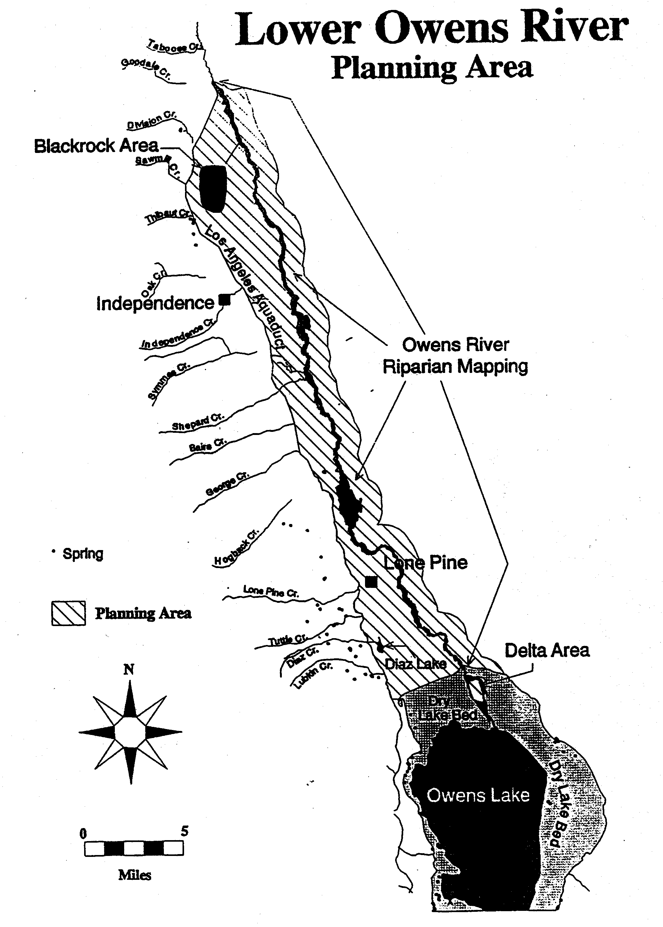
1. Lower Owens River Planning Area
2. Approximate Area of Initial Release to the Lower Owens River
3. Approximate Location of Pumpback Station and Approximate Area of Owens River Delta Habitat Area
4. Lower Owens River Project Blackrock Waterfowl Area
SECTION I – GENERAL PROVISIONS
A. PARTIES. The parties to this Memorandum of Understanding (“MOU”) are the City of Los Angeles Department of Water and Power (“DWP”), the County of Inyo (“County”), the California Department of Fish and Game (“DFG”), the California State Lands Commission (“SLC”), the Sierra Club (“SC”), and the Owens Valley Committee (“OVC”). These entities are collectively referred to as the “Parties.”
B. INTRODUCTION. This MOU provides resolution of the conflict and settles concerns between the above named parties over the Lower Owens River Project and other provisions of DWP’s 1991 environmental impact report (“EIR”) concerning groundwater pumping operations and related activities. DWP wrote the EIR seeking to satisfy an outstanding writ of mandate issued by the Third District Court of Appeal in County of Inyo v. City of Los Angeles, et al., 3 Civil C004068. The Court of Appeal granted amicus status to the DFG, the SLC, the SC, and the OVC to help determine the adequacy of the EIR.
This MOU will become effective upon unconditional discharge of the Court’s writ. Should the writ not be unconditionally discharged, this MOU shall have no effect on the appellate court litigation and shall not affect the positions of the Parties. The commitments contained in this MOU are made solely for the purpose of resolving the conflict. The MOU shall not be interpreted as an admission by any party to this MOU.
C. INYO COUNTY-LOS ANGELES LONG TERM WATER AGREEMENT. The overall goal of the Agreement is to manage water resources within Inyo County to avoid certain described decreases and changes in vegetation and to cause no significant effect on the environment which cannot be acceptably mitigated, while providing a reliable supply of water for delivery to Los Angeles and for use in Inyo County. Except as it modifies the scope of the Lower Owens River Project as described in the Inyo County/Los Angeles Long Term Water Agreement approved in October 1991 (“Inyo-Los Angeles Agreement”), nothing in this MOU affects any other provision of that agreement.
D. DEFINITIONS. Adaptive Management: As used in this MOU, adaptive management means a method for managing the Lower Owens River Project (section II below) that provides for modifying project management to ensure the project’s successful implementation, and/or the attainment of the project goals, should ongoing data collection and analysis reveal that such modifications are necessary. (See section II.E.)
Biodiversity: The variety and relative abundance of plant and animal species associated with a given area.
Consultants: As used in this MOU, the word “Consultants” means Ecosystem Sciences, or their successors. To secure Consultants’ services, DWP has entered into a three year contract with Consultants which includes provisions for performance of work to be undertaken by Consultants pursuant to this MOU.
Ecosystem: An interacting system of organisms considered together with their environment; for example, marsh, watershed and lake ecosystems.
Feasible: For the purposes of this MOU, feasible means capable of being accomplished in a successful manner within a reasonable period of time, taking into account economic, environmental, legal, social and technological factors.
Holistic Management of Natural Resources: Management of ecosystems, including the human, financial and biological resources, to produce a desired goal of a healthy ecosystem.
Inyo County/Los Angeles Standing Committee: The Inyo County/Los Angels Standing Committee (“Standing Committee”) was formed pursuant to a Memorandum of Understanding between the County and the City of Los Angeles in 1982. The Inyo-Los Angeles Agreement provides that the Standing Committee will represent the County and the City of Los Angeles in implementing the goals and principles of that agreement. That agreement provides that the representatives of the City of Los Angeles on the Standing Committee shall include at least one member of the Los Angeles City Council, the Administrative Officer of the City of Los Angeles, two members of the Board of Water and Power Commissioners, and three DWP staff members. The County representatives on the Standing Committee shall include at least one member of the Inyo County Board of Supervisors, two members of the Inyo County Water Commission, and three staff members. The Inyo-Los Angeles Agreement provides that regardless of the number of representatives from either the County or the City of Los Angeles in attendance at a Standing Committee meeting, the County shall have one vote and the City of Los Angeles shall have one vote. In the event of a tie vote at the Standing Committee, the Inyo-Los Angeles Agreement sets forth dispute resolution procedures to resolve the issue.
Inyo County/Los Angeles Technical Group: The Inyo County/Los Angeles Technical Group (“Technical Group”) was formed pursuant to a Memorandum of Understanding between the County and the City of Los Angeles in 1982. The Inyo-Los Angeles Agreement provides that the Technical Group will assist the County and the City of Los Angeles in implementing the goals and principles of that agreement. That agreement provides that the Technical Group shall be comprised of five representatives selected by the County and five representatives selected by DWP. The Inyo-Los Angeles Agreement provides that regardless of the number of representatives from either the County or the City of Los Angeles in attendance at a Technical Group meeting, the County shall have one vote and DWP shall have one vote. In the event of a tie vote at the Technical Committee, the Inyo-Los Angeles Agreement sets forth procedures for the Standing Committee to resolve the issue.
Sustainable Uses: Utilization of natural resources through time without causing environmental degradation.
Threatened and Endangered Species: For the purposes of this MOU, Threatened and Endangered Species shall be all native plant and animal species listed as such under federal or state laws and regulations adopted pursuant to such federal or state laws.
Wetlands: Those areas that are inundated or saturated by surface or groundwater at a frequency and duration sufficient to support, and that under normal circumstances do support, a prevalence of vegetation typically adapted for life in saturated soil conditions.
SECTION II – LOWER OWENS RIVER PROJECT
The Lower Owens River Project (“LORP”) was identified in the EIR as compensatory mitigation for impacts that were considered difficult to quantify or mitigate directly. The project described in the EIR includes the rewatering of the Lower Owens River channel below the aqueduct intake, the enhancement of several environmental features along and near the river, and the return of water to the aqueduct by means of a pumpback facility near the Owens River delta. The LORP will be augmented to include the development and implementation of an ecosystem management plan for the Lower Owens River area as described below that incorporates multiple resource values and provides for management based upon holistic management principles.
A. LORP PLAN. DWP and the County will direct and assist Consultants in the preparation and implementation of the LORP ecosystem management plan (“LORP Plan”). The procedures to be followed in the preparation of the plan are described in the “Lower Owens River Ecosystem Management Plan–Action Plan and Concept Document” which is Attachment A to this MOU and is incorporated by reference (“Action Plan”). The Action Plan is based upon the LORP Phase I and LORP Phase II studies which were performed by Mr. Mark Hill, Dr. Bill Platts and others for Don Chapman Consultants, Inc. The Action Plan will be modified as necessary to be consistent with the goals for the LORP as set forth in this MOU. (The protocol for the Phase I study and the executive summary of the Phase II study are Appendices 1 and 2, respectively, to the Action Plan.)
1. The LORP Plan will apply to all lands owned by the City of Los Angeles in the Owens Valley located within the approximate area shown on Figure 1 (“Planning Area”). The plan will address the four physical features of the LORP: (1) the Lower Owens River Riverine-Riparian Ecosystem, (2) the Owens River Delta Habitat Area, (3) Off-River Lakes and Ponds, and (4) the Blackrock Waterfowl Habitat Area. The plan will also include any other riparian areas, wetlands, marshes, meadows and springs and seeps within the Planning Area.
2. The Action Plan includes the development of the following plans that will be integrated to comprise the overall LORP Plan:
a. “Management Plan for the Lower Owens River Riverine-Riparian Ecosystem”b. “Wildlife and Wetlands Management Plans”c. “Habitat Conservation Plan”d. “Land Management Plan”e. “Monitoring and Reporting Plan”
B. GOAL OF THE LORP. The goal of the LORP is the establishment of a healthy, functioning Lower Owens River riverine-riparian ecosystem, and the establishment of healthy, functioning ecosystems in the other physical features of the LORP, for the benefit of biodiversity and Threatened and Endangered Species, while providing for the continuation of sustainable uses including recreation, livestock grazing, agriculture and other activities. The goal of the LORP includes:
1. Establishment and maintenance of diverse riverine, riparian and wetland habitats in a healthy ecological condition. The LORP Action Plan identifies a list of “habitat indicator species” (Table 1, Attachment A) for each of the areas associated with the four physical features of the LORP. Within each of these areas, the goal is to create and maintain through flow and land management, to the extent feasible, diverse natural habitats consistent with the needs of the “habitat indicator species.” These habitats will be as self-sustaining as possible.
2. Compliance with state and federal laws (including regulations adopted pursuant to such laws) that protect Threatened and Endangered Species.
3. Management consistent with applicable water quality laws, standards and objectives.
4. Control of deleterious species whose presence within the Planning Area interferes with the achievement of the goals of the LORP. These control measures will be implemented jointly with other responsible agency programs.
5. Management of livestock grazing and recreational use consistent with the other goals of the LORP.
Additional goals for each of the features of the LORP are described in section II.C below.
C. PHYSICAL ENVIRONMENTAL FEATURES. The LORP Plan will provide that the four physical features of the LORP will be implemented and managed as set forth below.
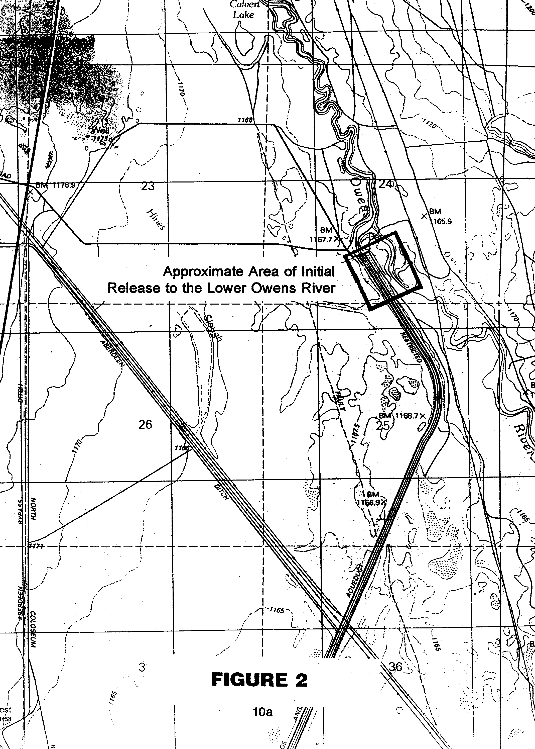
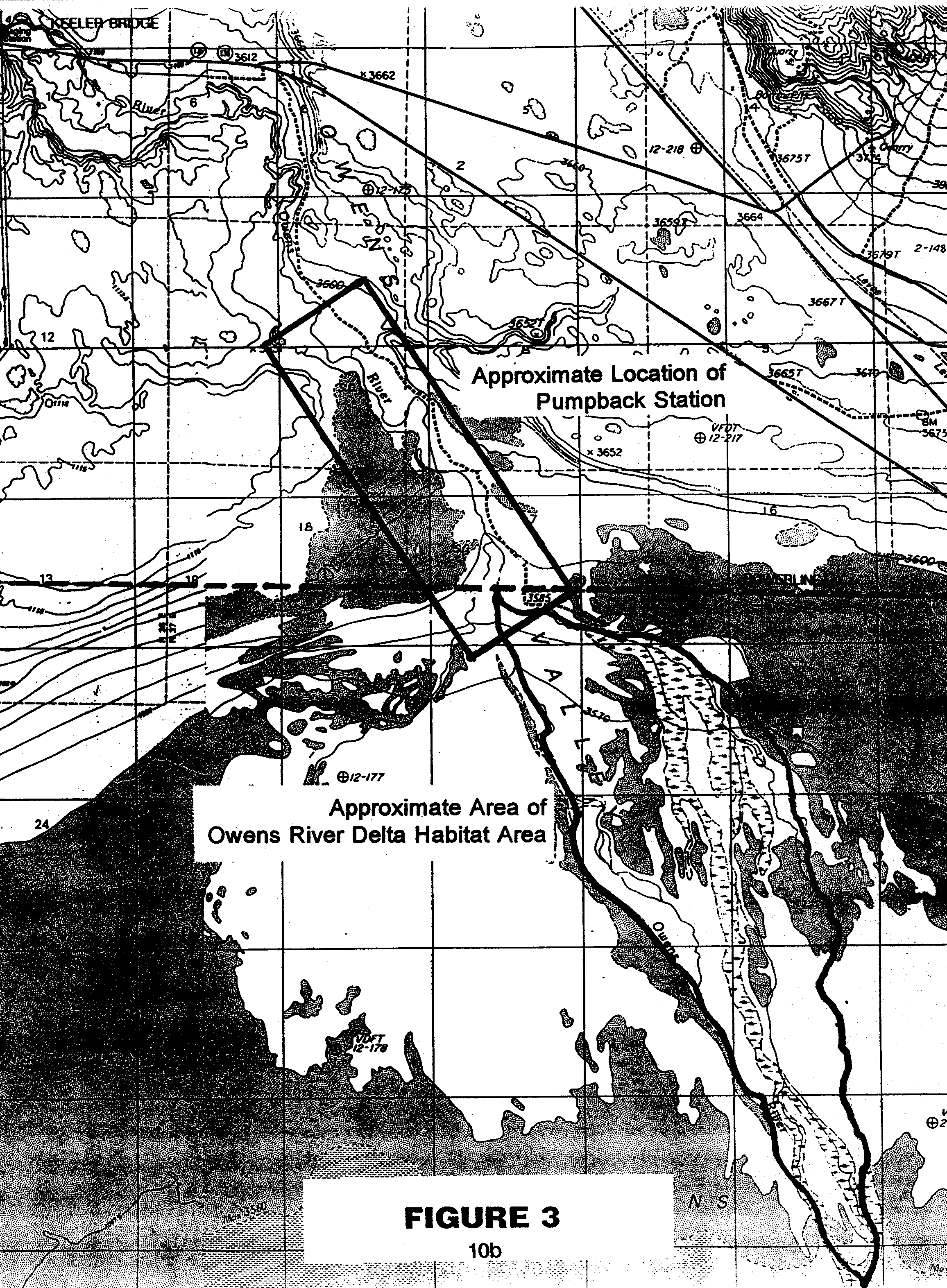
1. The Lower Owens River Riverine-Riparian System. A continuous flow will be established and maintained in the river channel from at or near the intake structure which diverts the Owens River into the Los Angeles Aqueduct (“Intake”) to a pumpback system located near the river delta which will convey water from the river to the Los Angeles Aqueduct. Any water in the river channel that is above the amount specified in this MOU for release below the pumpback system to supply the Owens River Delta Habitat Area will be recovered by the pumpback system for delivery to Los Angeles. The area near the Intake within which water will be released to the river is shown on Figure 2 and the area within which the pumpback system will be constructed is shown on Figure 3.
a. The goal for the Lower Owens River Riverine-Riparian System is to create and sustain healthy and diverse riparian and aquatic habitats, and a healthy warm water recreational fishery with healthy habitat for native fish species. Diverse natural habitats will be created and maintained through flow and land management , to the extent feasible, consistent with the needs of the “habitat indicator species” for the riverine-riparian system. These habitats will be as self-sustaining as possible. Management of flows in the riparian-riverine system will be consistent with the flow regime set forth below.
b. The flow regime within the riverine-riparian system will be as follows:
i. A base flow of approximately 40 cfs from at or near the Intake to the pumpback system to be maintained year round.
ii. A seasonal habitat flow. It is currently estimated that in years when the runoff in the Owens River watershed is forecasted to be average or above average, the amount of planned seasonal habitat flows will be approximately 200 cfs, unless the Parties agree upon an alternative habitat flow, with higher unplanned flows when runoff exceeds the capacity of the Los Angeles Aqueduct. (The runoff forecast for each year will be DWP’s runoff year forecast for the Owens River Basin, which is based upon the results of its annual April 1 snow survey of the watershed.) In years when runoff is forecasted to be less than average, the habitat flows will be reduced from 200 cfs to as low as 40 cfs in general proportion to the forecasted runoff in the watershed. The amount of the annual habitat flow will be set by the Standing Committee, subject to any applicable court orders concerning the discharge of water onto the bed of Owens Lake and in consultation with DFG, and be based on the Lower Owens River Riverine-Riparian Ecosystem element of the LORP Plan, which will recommend the amount, duration and timing of flows necessary to achieve the goals for the system under varying hydrologic scenarios.
The purpose of the habitat flow is the creation of a natural disturbance regime that produces a dynamic equilibrium for riparian habitat, the fishery, water storage, water quality, animal migration and biodiversity which results in resilient and productive ecological systems. To achieve and maintain riparian habitats in a healthy ecological condition, and establish a healthy warm water recreational fishery with habitat for native species, the plan will recommend habitat flows of sufficient frequency, duration and amount that will (1) minimize the amount of muck and other river bottom material that is transported out of the riverine-riparian system, but will cause this material to be redistributed on banks, floodplain and terraces within the riverine-riparian system and the Owens River delta for the benefit of the vegetation; (2) fulfill the wetting, seeding, and germination needs of riparian vegetation, particularly willow and cottonwood; (3) recharge the groundwater in the streambanks and the floodplain for the benefit of wetlands and the biotic community; (4) control tules and cattails to the extent possible; (5) enhance the fishery; (6) maintain water quality standards and objectives; and (7) enhance the river channel.
iii. A continuous flow in the river channel will be maintained to sustain fish during periods of temporary flow modifications.
c. Appropriately placed gaging stations in sufficient numbers (to include at least 4 stations) to measure and manage the flow in the river channel will be established as identified in the LORP Plan. These stations will be sited so that flow can be managed in each of the hydrologically varying sections of the river channel in order to meet the goals and objectives of the LORP.
2. The Owens River Delta Habitat Area. The area of this feature is shown on Figure 3. The goal is to enhance and maintain approximately 325 acres of existing habitat consisting of riparian areas and ponds suitable for shorebirds, waterfowl and other animals and to establish and maintain new habitat consisting of riparian areas and ponds suitable for shorebirds, waterfowl and other animals within the Owens River Delta Habitat Area. Diverse natural habitats will be created and maintained through flow and land management, to the extent feasible, consistent with the needs of the “habitat indicator species” for the Owens River Delta Habitat Area. These habitats will be as self-sustaining as possible.
Subject to applicable court orders concerning the discharge of water onto the bed of Owens Lake, the quantity of water that will be released below the pumpback station for these purposes will be an annual average of approximately 6 to 9 cfs (not including water that is not captured by the station during periods of seasonal habitat flows). The portion of the Wildlife and Wetlands Management Plan element of the LORP Plan which addresses the Owens River Delta Habitat Area will, in view of the quantity of water to be released below the pumpback system, determine the amount of water needed to maintain existing habitats, to enhance existing habitats, and to create new habitats, and will determine the amount and use of seasonal habitat flows. The plan will evaluate the feasibility and the relative environmental benefits of the enhancement of existing habitat and the establishment of new habitats. Based upon this evaluation, the plan will recommend how existing habitats should be maintained, which existing habitats should be enhanced, what new habitats should be established, and how the water should be released and used so that these habitats are maintained in a healthy ecological condition.
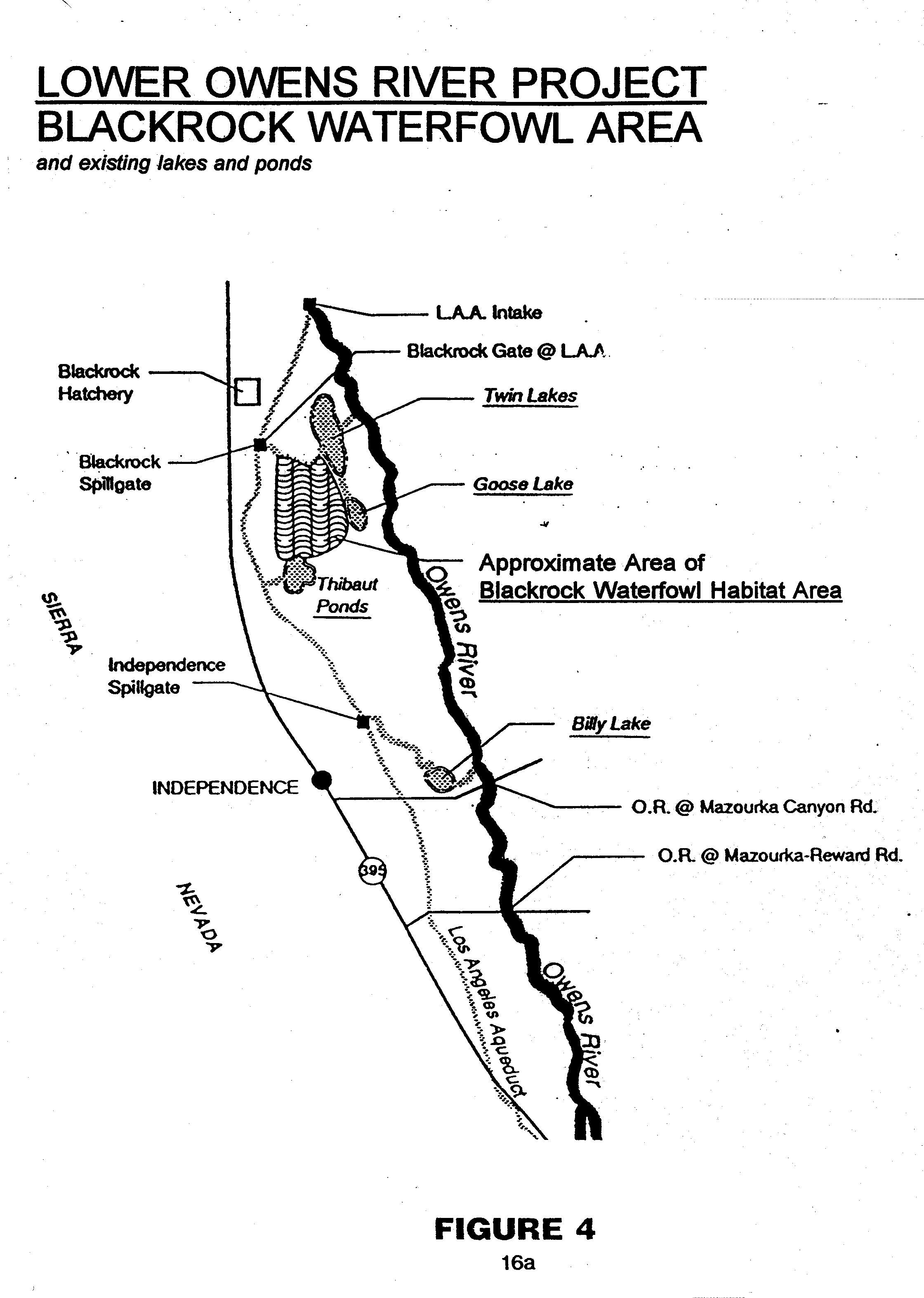
3. Off-River Lakes and Ponds. These features are shown on Figure 4. The goal is to maintain and/or establish these off-river lakes and ponds to sustain diverse habitat for fisheries, waterfowl, shorebirds and other animals as described in the EIR. Diverse natural habitats will be created and maintained through flow and land management, to the extent feasible, consistent with the needs of the “habitat indicator species” for the Off-River Lakes and Ponds. These habitats will be as self-sustaining as possible.
4. The 1500-Acre Blackrock Waterfowl Habitat Area. The area of this feature is shown on Figure 4. The goal is to maintain this waterfowl habitat area to provide the opportunity for the establishment of resident and migratory waterfowl populations as described in the EIR and to provide habitat for other native species. Diverse natural habitats will be created and maintained through flow and land management, to the extent feasible, consistent with the needs of the “habitat indicator species” for the Blackrock Waterfowl Habitat Area. These habitats will be as self-sustaining as possible.
Approximately 500 acres of the habitat area will be flooded at any given time in a year when the runoff to the Owens River watershed is forecasted to be average or above average. In years when the runoff is forecasted to be less than average, the water supply to the area will be reduced in general proportion to the forecasted runoff in the watershed. (The runoff forecast for each year will be DWP’s runoff year forecast for the Owens River Basin, which is based upon the results of its annual April 1 snow survey of the watershed.) Even in the driest years, available water will be used in the most efficient manner to maintain the habitat. The Wildlife and Wetlands Management Plan element of the LORP Plan will recommend the water supply to be made available under various runoff conditions and will recommend how to best use the available water in dry years. The amount of acreage to be flooded in years when the runoff is forecasted to be less than average will be set by the Standing Committee based upon the recommendations of the Wildlife and Wetlands Management Plan and in consultation with DFG.
D. AGENCY CONSULTATION AND PUBLIC INVOLVEMENT. Consultation with the Parties, agencies, DWP ranch lessees, and the public concerned with the development and implementation of the LORP Plan will occur throughout the development and implementation of the LORP Plan.
E. MONITORING AND REPORTING PLAN – ADAPTIVE MANAGEMENT. Monitoring sites and water flow gaging stations will be identified and a program for data collection, analysis, and reporting (which will identify pathways to allow feedback to indicate where adaptive modifications to management are necessary) will be described as part of this plan. Should the reported information reveal that adaptive modifications to the LORP management are necessary to ensure the successful implementation of the project, or the attainment of the LORP goals, such adaptive modifications will be made.
F. LORP EIR. DWP as lead agency, and the County as responsible agency will jointly prepare an environmental impact report on the LORP. A draft LORP EIR will be released within 36 months of the discharge of the writ, and a final LORP EIR will be completed and presented for certification as soon as possible following the release of the draft. Extension of these deadlines may be granted by unanimous consent of the Parties or due to circumstances beyond the control of the DWP and/or the County.
G. PUMPBACK SYSTEM. Construction of the pumpback system will commence as soon as possible following the certification of the LORP EIR and will proceed as expeditiously as possible. Construction should be completed within 3 years after it is commenced.
H. IMPLEMENTATION. DWP will commence the baseflow of 40 cfs in the river channel by the 72nd month after the discharge of the writ unless circumstances beyond DWP’s control prevent the completion of the pumpback system and/or the commencement of the baseflow within the 72-month period. DWP will commence implementation of the other physical features of the LORP upon the certification of the LORP EIR.
In the event it becomes apparent that, due to circumstances beyond DWP’s control, the LORP cannot be implemented substantially as described in this MOU, DWP’s obligation, pursuant to the California Environmental Quality Act (“CEQA”), to mitigate for impacts described in the EIR is not excused. In such event, the Parties will meet and confer in good faith as expeditiously as possible to identify alternative mitigation that will comply with CEQA. If alternative mitigation is needed, DWP shall prepare a limited focus, supplemental environmental document which addresses such alternative mitigation. In the event that a supplemental environmental document is to be prepared, and subject to delay for circumstances reasonably beyond DWP’s control, a draft environmental document will be completed within approximately 18 months after it is determined that alternative mitigation is necessary, and a final document will be thereafter certified and approved as expeditiously as possible. CEQA shall govern the preparation and processing of the environmental document, including but not limited to the type of environmental document to be prepared, its contents, and the opportunity for public review and comment. Nothing in this paragraph alters the rights, obligations, defenses, or remedies of any party to this MOU.
I. PERMITS, APPROVALS, LICENSES. The Parties will work cooperatively with DWP and/or the County in obtaining, and will support the issuance of, any permits, approvals, licenses, leases, or agreements which are required by law and/or are necessary for the implementation of the LORP. However, this commitment is contingent upon the overall project description in the LORP EIR, and/or the activity associated with the permit, approval, license, lease, or agreement, being consistent with: (1) the recommendations of the Consultants with respect to the LORP, (2) the provisions of this MOU concerning the LORP (including the amount, duration, and timing of flows in the LORP), and (3) with any final result of dispute resolution or litigation concerning the LORP. Further, the Parties will not seek through any permit, approval, license, lease or agreement, or any procedure thereunder, to alter the recommendations of the Consultants with respect to the LORP, the provisions of this MOU concerning the LORP (including the amount, duration, and timing of flows in the LORP), or a final result of any dispute resolution or litigation concerning the LORP.
1. With regard to any such permits, approvals, licenses, leases, or agreements under the jurisdiction of DFG and/or SLC, DFG, SLC, and DWP shall provide notice to, and solicit the comments of, the other Parties hereto, and shall provide for the participation of the public. The Parties’ comments and participation shall be in good faith and in accordance with facilitating the implementation of the provisions of this MOU pertaining to the LORP.
2. Certain activities that must be undertaken as part of the implementation of the LORP may be subject to section 1601 of the California Fish and Game Code. The Parties agree to work cooperatively to develop a long-term section 1601 agreement with respect to the LORP that covers any such activities that are described and addressed in the LORP EIR.
a. Any activities or short-term projects associated with the LORP which are not described and addressed in the LORP EIR will not be covered by the long-term section 1601 agreement, and the provisions of section 1601 shall apply strictly to such projects or activities.
b. The Parties agree that the planning process specified in this MOU shall satisfy the notification requirement of section 1601 for the purpose of entering into the long-term 1601 agreement.
c. If the final EIR on the LORP has been certified by the 60th month after discharge of the writ, the time limits and dispute resolution provisions set forth in section 1601 will be waived by DFG. The 60-month period for the certification of the EIR on the LORP may be extended by mutual agreement of DFG, DWP and the County, or if circumstances beyond the control of DWP warrant an extension.
SECTION III – ADDITIONAL COMMITMENTS
A. STUDIES, EVALUATIONS AND COMMITMENTS. Under the direction of DWP and the County, Consultants and their associates will conduct the following studies and evaluations. Except as otherwise provided in this section, these studies and evaluations will be completed within three years of the discharge of the writ. Actions or projects recommended by these studies and evaluations will be presented to the Board of Water and Power Commissioners for approval and implementation as soon as possible following the completion of the study or evaluation and after compliance with CEQA. The Board of Water and Power Commissioners will make a decision on the action or project within 60 days after the recommendation is presented to the Board. If the Board determines not to implement all or part of any such action or project, it shall set forth its reasons therefor in a resolution of disapproval. In the event that an environmental impact report is required for any such action or project, the action or project may be evaluated as part of the LORP EIR. Actions or projects approved by the Board of Water and Power Commissioners will be implemented as expeditiously as feasible.
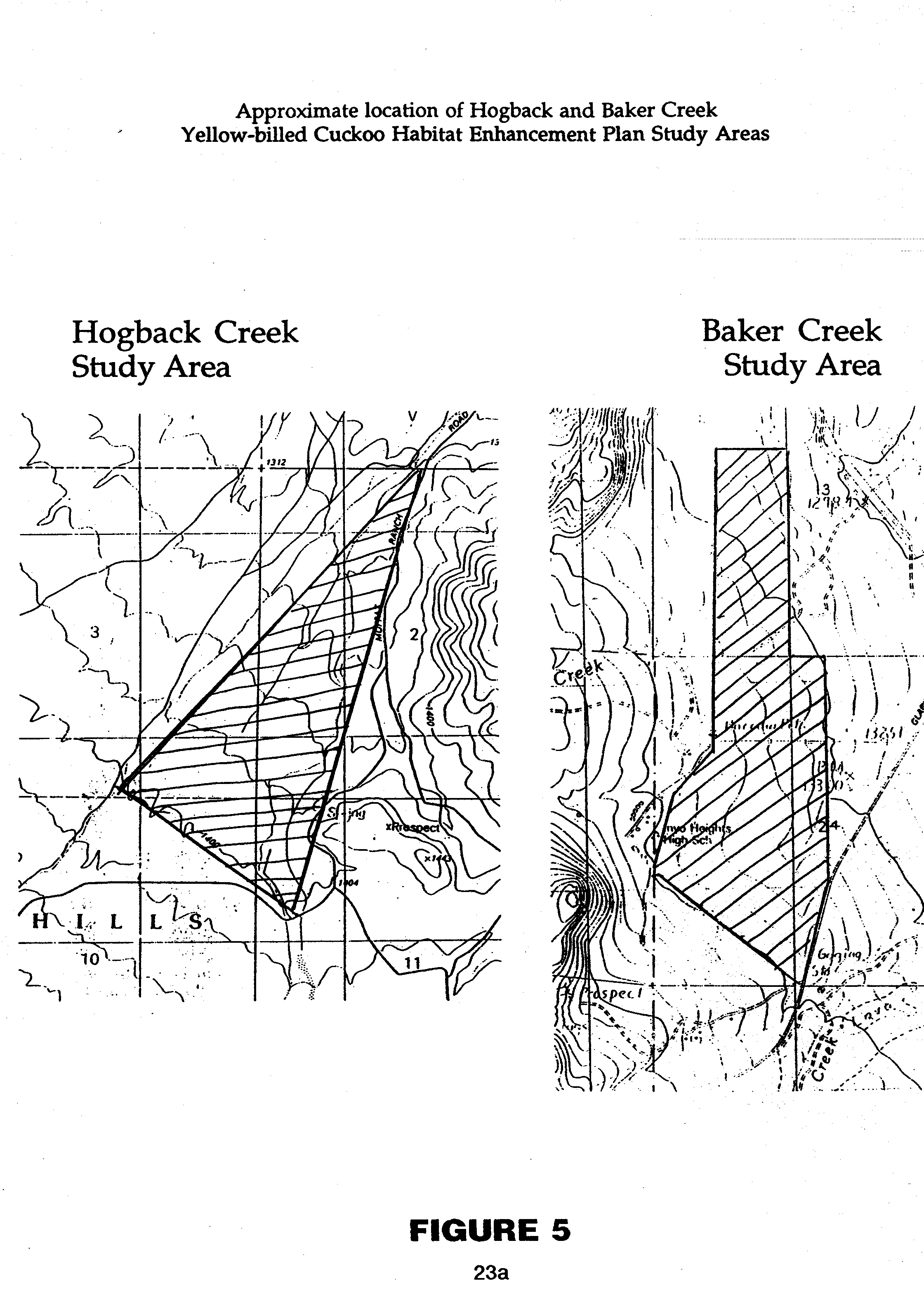
1. YELLOW-BILLED CUCKOO HABITAT. Consultants will conduct an evaluation of the condition of Yellow-billed Cuckoo habitat in the riparian woodland areas of Hogback and Baker Creeks shown on Figure 5. Based on that evaluation, Consultants will develop, as they deem warranted, Yellow-billed Cuckoo Habitat Enhancement Plans for these areas. Each plan will identify reasonable and feasible actions or projects to maintain and/or improve the habitat of the Yellow-billed Cuckoo. In developing the plans, the Consultants will consider the recommendations for these areas that were identified in the Distribution of Breeding Riparian Birds in Owens Valley, Inyo County, California (Laymon and Williams 1994) and will confer with DWP, the lessee for each area and the Parties.
2. INVENTORY OF PLANTS AND ANIMALS AT SPRINGS AND SEEPS (LORP Planning Area). An inventory of plants and animals at existing springs and seeps and associated wetlands on lands owned by the City of Los Angeles located within the LORP Planning Area will be conducted by Consultants. For the purposes of this section, the areas to be inventoried will be those areas naturally inundated or saturated by groundwater from springs and/or seeps at a frequency and duration sufficient to support, and that under normal circumstances do support, a prevalence of vegetation typically adapted for life in saturated soil conditions.
The inventory will provide a reasonably complete list of plants and animals occurring within each inventoried area, a quantitative or semi-quantitative measure of species abundance, and vegetation maps of each area. Survey methods will be employed that will be capable of revealing the existence of any Threatened and Endangered Species within the inventoried area. Under the Inyo-Los Angeles Agreement, the inventory will be used as a baseline to assist in monitoring whether there are any future changes in these species and/or their habitats, and if so, whether the changes are due to water management activities governed by that agreement. The inventory also will be used in the preparation of the LORP Plan.
3. ADDITIONAL MITIGATION. A total of 1600 acre feet of water per year will be supplied by DWP for (1) the implementation of the on-site mitigation measure at Hines Spring identified in the EIR, and (2) the implementation of on-site and/or off-site mitigation that is in addition to the mitigation measures identified in the EIR for impacts at Fish Springs, Big and Little Blackrock Springs, and Big and Little Seely Springs.
Consultants will determine the water requirements of the mitigation measure at Hines Spring. Once the water supply requirements have been determined, opportunities to use any remaining water in the implementation of on-site and/or off-site mitigation at/for Fish Springs, Big and Little Blackrock Springs, and Big and Little Seely Springs will be identified and evaluated by Consultants. The establishment of a shorebird and waterfowl habitat east of Diaz Lake, the enhancement of a wetland at Calvert Slough, and the establishment of a permanent water supply for Warren Lake north of Big Pine to enhance shorebird and wildlife habitat will be included in the evaluation of off-site measures. The feasibility and the relative environmental benefits of the identified opportunities also will be assessed.
Based upon this evaluation, Consultants will recommend reasonable and feasible mitigation measures in addition to the measure at Hines Spring and will recommend how the water should be released and used to implement and maintain these mitigation measures. Reasonable and feasible measures will be recommended which will provide the most environmental benefits that can be achieved with the available water. On-site mitigation measures will be preferred unless off-site measures are found to be more environmentally beneficial than identified on-site measures. In considering whether to recommend a measure, Consultants will confer with DWP, the lessee for each affected area and the Parties. Mitigation measures recommended by the Consultants, within the limits of 1600 AFY, will be implemented by DWP and will be maintained by DWP and/or the County.
B. OWENS VALLEY MANAGEMENT PLANS. The City of Los Angeles retains land holdings in the Owens Valley primarily to ensure protection of both surface and groundwater resources, and to enable sustained water supply to meet the needs of the citizens of Los Angeles. As financial and personnel resources become available, but not later than 5 years after discharge of the writ, DWP will commence the preparation of management plans for Los Angeles-owned, non-urban lands within the portion of the Owens River watershed located in Inyo County not included in the LORP Planning Area. (These lands are hereinafter collectively referred to as the “Management Area.”) Within the Management Area, DWP, in consultation with the Parties and others, will identify and prioritize for plan development, those areas where problems exist from the effects of livestock grazing and other land uses. The Parties will have the opportunity to review and comment on a written description of the areas identified, and the reasons for their prioritization, before plan development. The first level of priority will be given to riparian areas, irrigated meadows and sensitive plant or animal habitats. The plans will use the work done and underway in the Long Valley and Upper Owens River areas as a model where appropriate. Opportunity for Party, agency and public review of the proposed plans will be provided. The process will comply with applicable provisions of CEQA.
As with the LORP Plan described above, the management plans will consider multiple resource values, and will provide for management based upon holistic management principles. While providing for the primary purpose for which Los Angeles owns the lands, including the protection of water resources utilized by the citizens of Los Angeles, the plans will also provide for the continuation of sustainable uses (including recreation, livestock grazing, agriculture, and other activities) will promote biodiversity and a healthy ecosystem, and will consider the enhancement of Threatened and Endangered Species habitats. Habitat conservation plans for Threatened and Endangered Species will be incorporated if and where appropriate.
Plans will include an implementation schedule for the purpose of addressing the problems identified in the planning areas, and a monitoring/reporting program. The plans will be prepared under the direction of Consultants and all plans will be completed within approximately 10 years of the discharge of the writ. As plans become final, they will be presented to the Board of Water and Power Commissioners for approval and implementation as expeditiously as possible, in accordance with the schedule set forth in the plan.
C. INVENTORY OF PLANTS AND ANIMALS AT SPRINGS AND SEEPS (Outside LORP Planning Area). Within 36 months of the discharge of the writ, DWP and the County will jointly complete an inventory of plants and animals at existing springs and seeps and associated wetlands on lands owned by the City of Los Angeles within the portion of the Owens River watershed located in Inyo County that is not included in the LORP Planning Area. For the purposes of this section, the areas to be inventoried will be those areas naturally inundated or saturated by groundwater from springs and/or seeps at a frequency and duration sufficient to support, and that under normal circumstances do support, a prevalence of vegetation typically adapted for life in saturated soil conditions.
The inventory will provide a reasonably complete list of plants and animals occurring within each inventoried area, a quantitative or semi-quantitative measure of species abundance and vegetation maps of each area. Survey methods will be employed that will be capable of revealing the existence of any Threatened and Endangered Species within the inventoried area. Under the Inyo-Los Angeles Agreement, the inventory will be used as a baseline to assist in monitoring whether there are any future changes in these species and/or their habitats, and if so, whether the change is due to water management activities governed by that agreement. The inventory also may be used in the preparation of management plans that address the inventoried area.
D. TYPE E VEGETATION. Within 30 months of the discharge of the writ, using aerial photographs, transect data, and other relevant information, baseline conditions for vegetation identified as “Type E” in the Inyo-Los Angeles Agreement will be adopted by the Standing Committee. These baseline conditions will be used in the management of this vegetation under that agreement, in the preparation of the LORP Plan, and in the preparation of any other management plans that address the area.
E. AERIAL PHOTO ANALYSIS. DWP, the County, and experts in the field of aerial photography interpretation will conduct the aerial photo study outlined in the Request for Proposals “Owens Valley Aerial Photography Study” (November 1993) prepared by the Technical group.
1. The study will be completed within 36 months of the discharge of the writ. The study will:
a. evaluate the merits of utilizing aerial photo analysis in monitoring vegetation in the Owens Valley,
b. determine the feasibility of using existing air photos to analyze and refine the 1984-1987 vegetation map data base,
c. and develop recommendations on how aerial photography or other remote sensing techniques could be used in the future, if feasible, to monitor vegetation conditions and changes.
2. If feasible and cost-effective relative to other field monitoring techniques, DWP and the County will cooperatively implement the recommendations of the “Owens Valley Aerial Photography Study.”
F. MITIGATION PLANS FOR IMPACTS IDENTIFIED IN THE EIR AND THE INYO-LOS ANGELES AGREEMENT. The Technical Group will prepare mitigation plans and implementation schedules for all areas for which on-site mitigation measures have been adopted in the EIR. These plans will be prepared in accordance with the procedures set forth in section I.C.2 of the Green Book. (The Green Book is the technical appendix to the Inyo-Los Angeles Agreement.) The plans will be completed within 12 months of the discharge of the writ. The content of the mitigation plans will be in accordance with the EIR, which provides that on-site mitigation will be accomplished through revegetation with native Owens Valley species and through establishment of irrigation. The mitigation plans may include schedules for conducting research and testing revegetation techniques.
As reliable methods are developed for large-scale revegetation applicable to the different characteristics of the affected areas, the initial revegetation goals contained in the EIR, or in the initial plan, for each site will be refined or modified as necessary. In refining or modifying the revegetation goals for the affected areas, a preference will be given to revegetation that will restore the area to vegetation conditions similar to those that previously existed. If this cannot be feasibly and reliably accomplished because of the characteristics of the area, or for other reasons, the next preference will be to establish perennial vegetation comparable to that in nearby areas. If this is not feasible, revegetation with other native Owens Valley species will be the preferred goal.
G. TECHNICAL GROUP MEETINGS. All scheduled meetings of the Technical Group will be open to the public. Any other communications occurring between the representatives of the County and DWP shall not constitute Technical Group meetings.
H. ANNUAL REPORT ON OWENS VALLEY. DWP and the County will prepare an annual report describing environmental conditions in the Owens Valley and studies, projects, and activities conducted under the Inyo-Los Angeles Agreement and this MOU. Copies of the report will be distributed to the other Parties and made available to the public. The report will be released on or about May 1 of each year. The report will either be in the form of an executive summary, or it will contain an executive summary.
I. REPORTS. Reports, studies, evaluations, and analyses prepared pursuant to this MOU, together with supporting data, will be made available to the public. As draft and final documents and data become available, one copy of the document or data will be provided to each party. The public will be notified as final documents become available for review and copying.
The Parties acknowledge that DWP and DFG have reached agreement concerning Threatened and Endangered Species that involves land management and other activities in the Fish Slough area of Mono County. The agreement between DWP and DFG will be memorialized in a letter from DWP to DFG.
SECTION V – SELECTION OF A SUCCESSOR TO CONSULTANTS
As a result of their education, training, experience and philosophical approach, Consultants’ concept of resource planning is based upon holistic management principles with a goal of promoting biodiversity and sustainable uses. For this reason, and based upon their professional record and their exercise of independent judgment, the Parties have agreed to vest Consultants with the responsibility to develop many of the plans identified in this MOU.
Because of the Parties’ reliance on Consultants to successfully achieve many of the objectives of this MOU, should Ecosystems Sciences and/or one of its principal scientists (Mr. Mark Hill and Dr. Bill Platts) become unavailable, the Board of Water and Power Commissioners will choose a successor or successors who, in the view of the Parties possess the education, training, experience, ability and philosophical approach similar to Consultants. (These requirements apply equally to the selection of a staff member or members from DWP and/or the County to succeed Consultants.) The Parties acknowledge that many of the objectives of the MOU cannot be performed or implemented until a qualified successor(s) is agreed upon by the Parties. Therefore, the Parties will meet and confer in good faith to identify a qualified successor(s) as quickly as possible. If Consultants are available to suggest a potential successor or successors, they will be requested to provide their suggestions to the Parties. DWP, through its Board of Water and Power Commissioners, will make the final decision on the retention of any successor consultants; however, a successor(s) will not be retained who in the opinion of at least three of the parties is unqualified, provided said parties object in writing to the Board setting forth their reasons as to the lack of qualifications of the proposed successor.
SECTION VI – DISPUTE RESOLUTION
Each party to this agreement agrees to maintain frequent, informal communications with the other parties with regard to the work to be accomplished hereunder to minimize disagreements.
If any party to this agreement reasonably believes that any other party is not reasonably discharging an obligation or performing a duty which this agreement requires of that party, prior to commencing any litigation over such issue, the complaining party must bring the dispute to the attention all of the Parties through written notification that sets forth the nature of the dispute. The complaining party’s written notice must also contain a request for a meeting at Bishop, California, or any other mutually agreeable location, to be held within 7 days to discuss the dispute and suggest solutions. The Parties agree they will attend all such meetings.
In the event that the dispute has not been resolved within 14 days of the first meeting of the Parties, a mutually acceptable impartial mediator/facilitator may, by agreement of the Parties, be selected by the Parties to commence mediation\facilitation. The agreement of the Parties to commence mediation\facilitation shall identify which parties will participate in the mediation/facilitation, the method for selecting the mediator/facilitator, and how the costs of the mediator/facilitator will be allocated among the Parties. Any party who chooses not to participate in the mediation/facilitation must, prior to any agreement of the Parties concerning mediation/facilitation, notify the other parties in writing of such decision. The written notice must also state whether or not the party electing to not participate will agree to be bound by a resolution of the disputed issue agreed to by the participating parties and whether or not the non-participating party will waive its right to commence an action in court over such a resolved issue.
If the participating parties are unable to resolve the dispute within 21 days after the 1st meeting with the mediator/facilitator, the mediator/facilitator shall prepare a written recommendation on how the dispute may be resolved. The recommendation will be submitted to the participating parties within 30 days of the 1st meeting with the mediator/facilitator. The participating parties shall decide within 15 days of the submission of the recommendation whether to implement the recommendation. If the participating parties do not unanimously agree to implement the recommendation of the mediator/facilitator within the 15 day period, the recommendation will not be implemented. All Parties will be promptly notified of the result of the dispute resolution process. Any communications involving the participating parties and/or the mediator/facilitator arising out of an ongoing mediation/facilitation process will be kept confidential by the Parties. Any such communications, and any result of mediation/facilitation, may not be introduced in any court action unless otherwise expressly agreed in writing by the Parties.
If a Party reasonably believes that any other Party has breached this agreement by failing to discharge an obligation or perform a duty required of it, then such party may institute an action for declaratory and injunctive relief, as appropriate, in the Superior Court of Inyo County within 180 days of such breach or within 30 days of the written notification to the Parties of the result of the dispute resolution process, whichever occurs earlier. If a Party commences an action to enforce the provisions of this MOU, the Parties agree that they will jointly file a motion for expedited calendaring which requests that the matter be set for hearing within 90 days of the commencement of the action.
The Parties reserve the right to amend this MOU by unanimous written agreement of the Parties.
SECTION IX – FINANCIAL PROVISIONS
Within 90 days after the discharge of writ, the County will pay the sum of $53,000 to SC, and the sum of $30,000 to OVC for professional services in the development and preparation of this MOU.
SECTION X – SERVICE AND NOTICE
Any notices or service required by this MOU from one Party to another shall be in writing and may be sent by certified mail, personal delivery, facsimile or private courier. Notice shall be considered given or service complete either (a) when delivered to the recipient, or (b) on the date shown on the return receipt when deposited. Notices and service shall be to the following addresses:
DWP:
Northern District EngineerLos Angeles Department of Water and Power300 Mandich StreetBishop, California 93514
County:DirectorInyo County Water Department163 May StreetBishop, California 93514
DFG:
Department of Fish and Game1416 Ninth StreetP.O. Box 944209Sacramento, California 94244-2090Attention: General Counsel, Room 1335and
Department of Fish and Game407 West Line StreetBishop, California 93514
SLC:
State Lands Commission100 Howe Avenue, Suite 100 SouthSacramento, California 95825Attention: Legal Department
SC:
Mark BagleyP.O. Box 1431Bishop, California 93515andAlex LevensonGeneral Counsel, Sierra Club85 2nd StreetSan Francisco, California 94105
OVC:
Carla Scheidlinger393 Mt. Tom RoadBishop, California 93514
Any Party may change their address by notice in writing to all other Parties.
/
The Parties agree as set forth above.
CALIFORNIA STATE LANDS COMMISSION
Dated:
__________________________________________By: Robert HaightExecutive Officer CALIFORNIA DEPARTMENT OF FISH AND GAME
Dated:
__________________________________________By: Jacqueline E. SchaferDirector SIERRA CLUB
Dated:
__________________________________________By: Carl PopeExecutive Director OWENS VALLEY COMMITTEE
Dated:
__________________________________________By: Mary DeDeckerPresident CARLA SCHEIDLINGER
Dated:
__________________________________________By: Carla Scheidlinger COUNTY OF INYO
Dated:
__________________________________________By: Robert E. Michener, ChairmanInyo County Board of Supervisors CITY OF LOS ANGELESDEPARTMENT OF WATER AND POWER
Dated:
__________________________________________By: Carolyn L. Green, PresidentBoard of Water and Power Commissioners of the City of Los AngelesCITY OF LOS ANGELES
Dated:
__________________________________________By: John Ferraro, PresidentCity CouncilCity of Los Angeles