Revegetation Plan – Groundwater Pumping
Revegetation Plan continued:
The four sites listed below are identified in the EIR as being degraded due to groundwater pumping. They were the most variable of the sites visited. All of these sites still have remnant scattered patches of native shrubs.
| EIR Impact # | Site Location | Acres |
| 10-12 | Five Bridges | ~60 |
| 10-14 | Hines Spring | 1-2 |
| 10-11 | Tinemaha/Blackrock | |
| Charlie’s Butte | .4 | |
| Hines Spring S | — | |
| Blackrock 16E | 7.5 | |
| 10-13 | Independence | |
| Independence 105 | 13.4 | |
| Independence 131 | 74.6 | |
| Independence 123 | 28.5 |
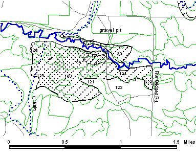 The Five Bridges Impact Area is located approximately 3.5 miles north of Bishop (Fig. 4) and is easily accessed from Five Bridges Rd. (T6S R33E, Sec.24). Before the combined impact of groundwater pumping, fire, and drought, this site was mapped as a complex of riparian, meadow, and upland plant communities. The original impact area encompassed approximately 300 acres, including all or portions of the following vegetation parcels located on the Fish Slough 7.5’ USGS quad: 42, 53, 54, 124, 125, 126, 129, and 130 (primarily in T6S R32E, Sec. 24). Since the impact was identified, remedial measures have mitigated approximately 80% of the area. This mitigated area is seasonally grazed, however a fence prevents livestock from grazing on the unmitigated portion. The site also provides access to the Owens River for recreational use.
The area still requiring mitigation is predominately mapped as Alkali Meadow and encompasses vegetation parcel nos. 53, 123, 124, 125, and one narrow strip of Riparian Scrub along the river and meanders, parcel no. 54. Currently the unmitigated area has been severely infested by native and non-native weeds which will be an obstacle to future revegetation efforts.
Soils at the site were mapped as a complex of Torrifluvents-Fluvaquentic Endoaquolls, two stream terrace soils with 0-2% slopes. Both soils have moderate to moderately rapid permeability and are saline with potentially high ECs and SARs which may limit species available for revegetation. Torrifluvent soils comprise 60% of this map unit and are hummocky, ranging from loamy sand to silt loam below the surface layer, are well to poorly drained, and have moderate available water capacity and moderate wind erosion hazard. The Fluvaquentic Endoaquolls are oxbow and river meanders with coarse sand to silt loam with low to moderate available water capacity. Both wind and water erosion hazard is slight. Management considerations for this soil complex are to limit off-road vehicles to maintain soil depth and reduce soil erosion and graze only after soils have adequately drained.
In late 1995, Dr. Bill Platts of Ecosystem Sciences visited the site and produced a mitigation plan for LADWP in 1996 (Platts 1996) which Los Angeles has agreed to implement. Parts of the revegetation plan from Ecosystem Sciences are presented in italics.
Goal: Restore the area to a complex of vegetation communities with similar species composition and cover as exists at local similar sites. The goal will be attained when the desired vegetation conditions are achieved and are sustainable.
Live cover and composition numbers are from on-site mapping during the 1984-87 vegetation inventory. For Alkali Meadows, live cover goals are 60% composed of four different perennial species. Riparian Scrub live cover goals are 90% composed of four different perennial species. Composition numbers are 75% of the previously mapped number of species.
Priority: High – This site is currently receiving remedial action to control weeds. This process must continue before any additional rehabilitation work can occur.
Revegetation plan:
Map the site (1998).
Using a global positioning system (GPS), delineate areas that still require mitigation.
Eliminate all artificial irrigation of the project area (1998 – 2002).
Necessary irrigation will be supplied through planned high flows of the Owens River that will flood the area three times a year. This flooding regime should allow recovering vegetation to respond to more natural processes and assist natural recruitment rather than relying on artificial flows from irrigation ditches. The duration of the flows will be for a sufficient period of time to allow water to flow through the area for 24 hours. These pulse flows should be evaluated after 5 years to determine their effectiveness towards accomplishing the rehabilitation goals. The river flows should occur as follows:
May/June – This 24hr 700 cfs flow is intended to distribute willow and cottonwood seeds and plant parts along the riparian areas. This pulse will be timed to coincide with maximum seed set.
July 1 and August 1 – These two 660 cfs flows will recharge the banks and waterways during seedling growth.
Seed small areas of the burn with native species (2000 – 2002).
Site preparation will include fertilizing and controlling weedy plants by potentially burning or spraying with herbicide. Seeding will be done with a range drill.
Allow the water table to remain at its natural level (1998 – ongoing)
Permanently shut down pumping wells E/M #385 and E/M#386 .
Develop and implement a 10-year grazing plan (1998 – 2007).
This plan will exclude grazing from riparian zones and exclude grazing in upland areas during the growing season. Cattle guards will be installed at major use areas instead of gates. (Fencing and installation of cattle guards has been completed.)
Dead willows will not be removed or burned
Monitoring (1998 – ongoing)
Monitoring will consist of annual photopoints and annual reading of the two previously established vegetation transects. Line-point transects will be used to determine whether the site has met the goals stated above.
Species list:
This list for seed mixes includes species from Alkali Meadow and Riparian Scrub communities that existed on the site prior to impact.
Shrubs/Forbs/Trees:
cluster goldenweed1a
salix1a (tree and shrub)
Woods rose1a
Fremont’s cottonwood1a
Grasses/Grasslike:
alkali sacaton1a
beardless wildrye1a
saltgrass1a
Baltic rush1a
clustered field sedge1a
spikerush1a
The mitigation for Hines Spring, as stated in the EIR, is to provide pumped groundwater to the currently dry spring area. The water supply will be part of 1600 acre feet of “additional mitigation” defined in the MOU. The Hines Spring area will encompass approximately one to two acres and will be developed and implemented by Ecosystem Sciences and LADWP in accordance with the MOU. Therefore no revegetation plan is presented for this area in this report.
This impact description is broken into three areas, the first area referred to as Charlie’s Butte is approximately 0.25 mile south of Charlie’s Butte, Hines Spring S is located in the drainage of Hines Spring, and Blackrock 16E is approximately one mile SE of Hines Spring.
Charlie’s Butte
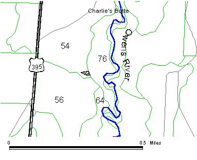
Revegetation Plan Figure 5
Charlie’s Butte Site
The Charlie’s Butte site was incorrectly mapped in the EIR according to D. Groeneveld (pers. com.). The actual impact site is near the mapped site and is easily accessed by roads to Charlie’s Butte (Fig. 5). Recent GPS mapping placed the site in parcel 54 but the vegetation demonstrated that it should have been in vegetation parcel 64. Parcel 64 is designated as Alkali Meadow with 33% live cover on the Tinemaha Reservoir 7.5’ USGS quad (T11S R34E, SE1/4NW1/4 Sec.11). Currently the 0.4 acre mitigation site has recovering alkali sacaton and juvenile Nevada saltbush which appear to be invading the area.
Soil at the site was mapped as Shondow loam with 0-2% slopes. The Shondow soils are fine-loamy, mixed, thermic Aquic Argixerolls. Water permeability is moderately slow with moderate available water capacity and subsoil salinity and sodicity is high. Susceptibility to wind erosion is moderate. Management suggestions include limiting off-road vehicles and careful grazing management.
Current impediments to natural recovery include off-road vehicle use, wind erosion, herbivory, groundwater pumping, and soil disturbance from rodents, livestock, and elk.
Goal: Restore vegetation conditions to that which existed prior to impact. The live cover goal is 33% and composition will be composed of at least three species, predominantly alkali sacaton. Other species that were mapped on this site include rubber rabbitbrush, Nevada saltbush, black greasewood, and Indian paintbrush.
Priority: High – Immediate protection may greatly simplify restoration and may be the only necessary action. Delaying action may greatly increase the difficulty due to weed infestation and further loss of plant cover and topsoil.
Revegetation plan:
Eliminate disturbances (1998).
Plant protection rather than fencing will be implemented because of the small size of the site (approximately 1/3 of an acre) and because a road runs through the middle. Alkali sacaton that are recovering will be protected. If only a few alkali sacaton are present, then transplants will be installed, watered, and protected (1999).
Site maintenance (1998 – ongoing)
Because the site has invading juvenile Nevada saltbush, maintenance may include their removal when they are within 0.5 m of a protected alkali sacaton. Removal of plants will take into consideration the potential for wind erosion.
Monitor (1999 – ongoing)
Initially monitoring will focus on the success of plant protection and the need for weed control. Additional plans for seeding, transplanting, and weed control will be developed if rehabilitation appears stalled or failing after three years (2001).
This site will require long-term monitoring after it has been revegetated to protect the site from changing community type and detecting weed invasions.
Revegetation Plan Figure 6
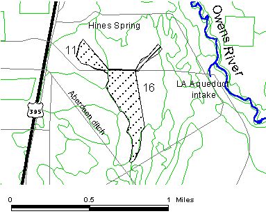
Hines Spring/Blackrock Sites
Hines Spring S
This site is located in the old drainage of Hines Spring (Fig. 6) and is located in vegetation parcels 11 and 16 on the Blackrock 7.5’ quad (T11S R34E, SE1/4NW1/4 and NE1/4SW1/4 (contiguous) Sec. 23). Because this area will likely be affected by the Hines Spring on-site mitigation, the site goal and revegetation plan for this area will be developed within three years after the work at Hines Spring is completed. Plans for the spring area will be completed by mid-2001.
This site is accessible from the Intake Rd. off Hwy. 395 approximately 2.25 mi. east of the community of Aberdeen (Fig. 6) on the Blackrock 7.5’ quad (T11S R34E, NE1/4SE1/4 Sec. 23). The EIR reported that this once included marsh, meadow, upland, and riparian plants, but it is now dominated by a sparse cover of shrubs. Wind erosion and grazing have further impacted the area in combination with groundwater pumping.
The site is currently used to graze packstock. The parcel was mapped as 297 acres of Alkali Meadow with 35% live cover. Fivehook bassia and Russian thistle made up 17% and 11% of the cover, respectively. The 7.5 acre mitigation portion of this parcel has little to no native vegetation. There is some natural recruitment of sagebrush and Nevada saltbush juvenile shrubs. Weeds are scattered throughout the area and fivehook bassia and tamarisk are mainly concentrated in the moister swales.
Soils at the site were mapped as Winnedumah silt loam, saline-sodic with 0-2% slopes. The Winnedumah soils are fine-loamy, mixed, thermic Xerollic Haplargids. The soil is calcareous in the top 41 inches, permeability is moderately slow, available water capacity is moderate to high and both salinity and sodicity are high in surface soil. The hazard of wind erosion is moderate. Management considerations include limiting off-road vehicles, grazing management, and planting only salt tolerant plants.
Current impediments to natural recruitment include packstock grazing, weed infestation, and difficult soils.
Goal: Rehabilitate the site to an Alkali Meadow similar to those within a 5 mi. radius of the site. The goal for live cover is 34%, composed of six species. Alkali sacaton and saltgrass should be the dominant species. The live cover goal was derived from the average live cover of the previously mentioned Alkali Meadows and composition was derived from the number of most commonly found species (excluding weeds) in those parcels.
Priority: High – Protection may begin the process of recovering the vegetation on the site. Delaying action may greatly increase the difficulty due to weed infestation and loss of topsoil.
Revegetation plan:
Eliminate disturbances (1998).
Fence the site to protect it from grazing.
Site maintenance (1998 – ongoing)
Site maintenance may include the removal of aggressive juvenile plants and weeds if they appear to compete with the recovery of desired species. Removal of plants will take into consideration the potential for wind erosion.
Monitor (1999 – ongoing)
Initially, monitoring will focus on recruitment and the need for weed control. Additional plans for seeding, transplanting, and weed control will be developed if rehabilitation appears stalled or failing during the first three years (2001).
Species list:
This species list for potential seed mixes and container plants only includes species from Alkali Meadows within a 5 mi. radius of the site. Aggressive native plants, such as Nevada saltbush, rubber rabbitbrush, and big sagebrush, were not included because they already exist on the parcel, and it is assumed they will spread without assistance. If monitoring demonstrates a paucity of species diversity then additional species will be added to this list.
Shrubs/Forbs:
black greasewood1a,1b,2
fourwing saltbush1b
shadscale2
Grasses:
alkali sacaton1a,1b,2
Great Basin wildrye2
saltgrass1a,1b,2
beardless wildrye1b
Revegetation Plan Figure 7
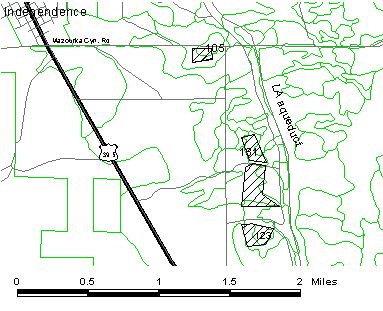
Independence Sites
This mitigation area consists of three sites referred to as Independence 105, Independence 131, and Independence 123 (Fig. 7). Independence 105 is accessed from Mazourka Cyn. Rd. and is approximately 1 mi. SE of the town of Independence. The other two are easily accessed from a dirt road off of Mazourka Cyn. Rd. and are approximately 2.25 (Independence 131) and 2.5 miles (Independence 123) SE of the town of Independence. All sites are located on the Independence 7.5’ USGS quad.
The soil at all the sites was mapped as complex of Morey family-Winnedumah, drained-Rindge family with 0-2% slopes. Morey family soils with similar inclusions comprise 40% of this map unit and are fine-silty, mixed, thermic Typic Argiaquolls. Winnedumah soils are fine-loamy, mixed, thermic Xerollic Haplargids. and with similar inclusions comprise 25% of this map unit. Rindge family soils are euic, thermic Typic Medisaprists and with similar inclusions comprise 20% of this map unit. All have moderately slow to slow permeability, high available water capacity, moderate to high shrink-swell capacity, and potentially high ECs and SARs. Management factors for revegetation include potential for wind erosion, inadequate drainage, salinity, and sodicity. Off-road vehicles should be limited and careful grazing management should be instituted on these soils.
The most northern site is in parcel no. 105 and is divided into north and south sections by Mazourka Canyon Rd.(T13S R35E, NE1/4NE1/4 Sec. 21). It was mapped as Nevada Saltbush Scrub with 5% plant cover, with Russian thistle and fivehook bassia making up 20% of the plant composition. After a site visit, it appeared that only the southern portion of the parcel, consisting of 13.4 acres, requires mitigation. Currently, there is recruitment of Nevada saltbush, fourwing saltbush, and allscale saltbush.
The middle site was mapped as parcel no. 131 (T13S R35E, SW1/4SW1/4 Sec. 22) consisting of 33 acres of Nevada Saltbush Scrub with 5% live cover. Fifty percent of the cover composition was annual forbs and 18% was Russian thistle. The boundaries of the revegetation area also include approximately half of vegetation parcel 125 (T13S R35E, NW1/4 Sec. 27) totaling 74.6 acres. This parcel was mapped as 129 acres of Desert Saltbush Scrub with 10% live cover consisting of 50% fourwing saltbush and 25% Russian thistle. This area was disturbed during the installation of a pipeline for a replacement well. The furrows from this disturbance are still visible and could be seeded with native seeds.
The most southern area was mapped as parcel no. 123 (T13S R35E, SW1/4 Sec. 27), 16 acres of Nevada Saltbush Scrub with 5% cover, 95% of the cover is Nevada saltbush. The impact extends to the west into parcel 231, 38.5 acres mapped as 8% live cover of Nevada Saltbush Scrub. In some areas, the wind has deposited sands on the leeward side of vegetation, however, the majority of the site has a hard soil surface with few “safe sites” for seed germination and seedling survival. Some natural recruitment is occurring along the southern boundary where wind erosion appears less severe. Remnant native plants are now confined to “shrub islands” or low-lying wetter areas.
Currently the sites are used for seasonal livestock grazing. Ongoing disturbances inhibiting natural revegetation include groundwater pumping, wind erosion, grazing, and invasion by weedy plants.
Goal: For Independence 105, 131, and 123. To revegetate with species mapped in surrounding communities. Historically the site supported species adapted to a shallow water table. Because current management no longer supports a high water table, it is assumed surrounding parcels represent the best estimate of those species that could be used to successfully revegetate the site.
Quantifiable goals were based on the five plant communities included in the species list below. The goal for live cover is 17% composed of four perennial plant species. These numbers were derived from the average live cover of the five plant communities and composition from half the number of species that will be tested on the sites.
Priority: Independence 105 – High – Because this site is showing natural recruitment, immediate protection may be the only action necessary. This site is slated for fencing in 1998. Independence 131 and 123 – High – These sites present the most difficult soil conditions and may require several years of experimentation to develop effective techniques. Thus, it would be beneficial to begin work as soon as feasible. These two sites are slated to be fenced in 1999.
Revegetation plan:
Independence 105
Eliminate disturbances (1998)
Fencing will be the main revegetation activity unless monitoring after three years indicates that further action is necessary (2001). Additional plans would likely include weed control, transplanting, and/or seeding.
Monitor (1999 – ongoing)
Independence 131
Eliminate disturbances (1999)
The site will be fenced.
Conduct more site specific soil characterization (1999).
On-site soil characterization and fertility tests will be conducted if they have proven useful at other sites.
Use container plants in test plots (start in 2001, transplant out 2002).
Containerized plants will be installed in windrows to reduce wind erosion. Plant protection will be provided for transplants.
Seed areas that have been previously ripped (2000) and test plots (2002).
Seeds will be broadcast and raked or drill seeded into soil that was ripped for pipeline installation and in test plots.
Mulch (2002)
Mulch will be spread in rows to catch soil, seeds, and litter, and to protect transplants if it has proven useful at other sites.
Test soil inoculation and/or soil amendments (2007).
Soil inoculation and/or soil amendments will be tested if seed and transplants continue to fail at the site. Sources and method for inoculation and amendments to be determined.
Site maintenance (2003 – ongoing)
Seeds in previously ripped soils will not be irrigated.
Monitor (2000 – ongoing)
Expand revegetation work (2007)
Based on results from test plots, plans for the entire site will be developed (2007) and implemented (2008).
Independence 123
Eliminate disturbances (1999).
This site will be fenced.
Use container plants in test plots (start in 2001, transplant out 2002).
Containerized plants will be installed in windrows to reduce wind erosion. Plant protection will be provided for transplants.
Seed (2002)
The site will be seeded in test plots if it has been used successfully at other sites with natural topography.
Mulch (2002)
Mulch will be spread in rows to catch soil, seeds, and litter, and to protect transplants if it has proven useful at other sites.
Expand revegetation work (2007)
Based on results from test plots, plans for the entire site will be developed (2007) and implemented (2008).
Site maintenance (2003 – ongoing)
Test soil inoculation (2007)
Soil inoculation will be tested if seed and transplants continue to fail at the site. Sources and method for inoculation to be determined.
Monitor (2000 – ongoing)
Independence 105, 131, and 123
Species list:
This list for seed mixes and container plants includes species from the following plant communities: Nevada Saltbush Scrub, Desert Sink Scrub, Desert Greasewood Scrub, Desert Saltbush Scrub, and Shadscale Scrub.
Shrubs/Forbs
allscale saltbush1a
desert olive4
inkweed1b
black greasewood1b,2
fourwing saltbush1a
Grasses:
alkali sacaton1b,2
saltgrass1b,2