Water Department
ICWD Home > Research and Reports > Annual Reports >
Table of Contents
Cover Page
Director's Report
Staff
Budget
Saltcedar Report
Precipitation
Mitigation
Vegetation
Soil Water Conditions
Groundwater Conditions
LORP Hydrology
Pumping History
Pumping 2008-2009
Bishop Cone Audit

Soil Water Conditions
The Water Agreement established procedures to determine which LADWP pumping wells can be operated based on soil water and vegetation measurements. Staff from ICWD regularly monitors depth to groundwater and soil water content at 25 sites in wellfields and eight sites in control areas. Data from 22 wellfield sites visited each month are used to determine the operational status (On or Off) of nearby pumping wells. Seven sites were in On-status through the 2008-09 runoff year. One site in Laws went into Off-status in October 2008.
 The purpose for the On/Off procedures is to manage pumping to protect
plant communities that require periodic connection to the water table for
long-term survival. Generally the sites with On-status have wet soil and
shallow water tables, and the Off-status sites have dry soil and deep water
tables. The On/Off determination is based on an incomplete accounting of the
components of the soil water balance, however. Sometimes On-status
sites are those with a deep water table and low plant cover. Conversely, a
site with adequate water table depth may be in Off-status if the water table
occurs just below the root zone and plant cover is high.
The purpose for the On/Off procedures is to manage pumping to protect
plant communities that require periodic connection to the water table for
long-term survival. Generally the sites with On-status have wet soil and
shallow water tables, and the Off-status sites have dry soil and deep water
tables. The On/Off determination is based on an incomplete accounting of the
components of the soil water balance, however. Sometimes On-status
sites are those with a deep water table and low plant cover. Conversely, a
site with adequate water table depth may be in Off-status if the water table
occurs just below the root zone and plant cover is high.
We identify the monitoring sites where the root zone is connected with the water table to give a better picture of the conditions underground that are affected by pumping. Several wellfield sites have an intermediate zone where soil water contents change little that separates lower depths affected by water table fluctuations from upper depths affected by precipitation. We rely on both soil water and groundwater data because the water table depth necessary to provide water to the plant roots depends on the soil characteristics as well as water table depth. For example, the capillary rise above the water table in a silty soil is much greater than in a sandy soil. For the same water table depth, the plants may have access to groundwater if the soil is silty, but not if it is sandy. How well plant roots can take up groundwater also depends on the type of vegetation. In similar soils, a shallower water table is necessary to supply groundwater to grasses than shrubs because of the shallower roots of the grasses. For management purposes, grass-dominated monitoring sites are assigned a root zone of 6.6 feet (2 m); shrub sites are assigned a root zone of 13.1 feet (4 m).
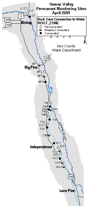
The wellfield monitoring sites (including three that are monitored but not used for pumping management) were grouped into simple categories to summarize the connection between the root zone and the water table. Brief descriptions of the three categories are given below:
- Connected: Water table fluctuations caused soil water changes in the top half of the root zone. Eight sites were placed in this category.
- Weakly connected: Water table fluctuations caused soil water changes in the bottom half of the root zone. Six sites occur in this category. Sites BP3, TA1, TS6, SS1, and BG2 have ample soil water stored in the soil profile.
- Disconnected: No recharge from lower depths is occurring in the root zone. Ten sites occur in this category compared with nine last year. Sites L2 and TA5 have retained soil water available to plants but the water table at the beginning of the 2009 growing season is probably too deep to recharge the root zone. Soil at the other sites is dry.
At the beginning of the 2009 growing season, the water table was capable of supplying water to the root zone at 15 monitoring sites located in wellfields (see map). This compares to about 16 sites last year. Most sites in the coupled and weakly connected categories had relatively moist soil in much of the soil profile. Two sites are probably not receiving groundwater in the root zone but have moist soil. The remaining eight sites have dry soil throughout the root zone.