2002-2003 Annual Report
2002-2003 Annual Report
The “Blue Crew” Saltcedar Eradication Team
Owens Valley Monitor is an account of monitoring and other work performed by the Inyo County Water Department and the Los Angeles Department of Water and Power. Under the Inyo/Los Angeles Water Agreement, the Water Department and LADWP monitor the effects of LADWP’s operations on groundwater levels and vegetation. The two agencies also jointly conduct scientific research to improve water management methods.
Table of Contents
- Saltcedar Program Ends Fifth Season
- LORP EIR/EIS Comments Are In, Agencies Will Respond to Public Concerns
- LADWP’s Eastern Sierra Exports
- Owens Valley Precipitation
- 2002-2003 LADWP Pumping
- LADWP Pumping and Uses on the Bishop Cone
- Owens Valley Water Uses
- LADWP Pumping by Wellfield 1971-2002
- Groundwater Conditions
- Vegetation Conditions
- Soil Water Conditions
- Research Aims to Improve Management
- Update on Memorandum of Understanding
- Status of Inyo/LA Water Agreement
- Inyo County’s Review of LADWP Mitigation
The Owens Valley Monitor 2002-2003
Saltcedar Program Ends Fifth Season — Brian Cashore, Saltcedar Project Manager
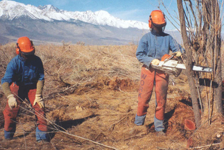
The Inyo County Saltcedar Control Program has completed its fifth year. Between October 2002 and March 2003, a chainsaw crew of nine worked southward cutting and removing non-native saltcedar (Tamarix ramosissima) from the Owens River channel approximately 17 miles below the Los Angeles aqueduct intake. California Department of Forestry crews cleared the cut material from the channel.
By the end of the season, the saltcedar crew removed the invasive shrub from 3.5 miles of river channel. This reach of the river contained the largest, densest stands of saltcedar in the Owens Valley. The biggest specimens were 20 feet tall, with trunks 22 inches in diameter. The dense, mature saltcedar monoculture may have been caused by several rock or earthen dams that the crew encountered in the channel. Water that ponded behind these dams could create fertile seedbeds for saltcedar to germinate and grow.
This past year was also significant because it was the first season the saltcedar program was almost wholly supported by grant funding. The Inyo County Water Department received two grants totaling $740,000 to control saltcedar in the LORP area. The grants came from the Wildlife Conservation Board and the Caltrans Environmental Enhancement and Mitigation Program. These funds will support saltcedar control through April 2004.
Downstream from the present work site and east of Independence, Russian olive (Elaeagnus angustifolia) has invaded the river channel. Like saltcedar, this plant was imported intentionally as an ornamental tree. Unfortunately, the qualities that made these plants easy to grow allowed them to escape cultivation. Once “escaped,” these highly adaptable and hearty species flourish in habitats disturbed or altered by human activities. Though used to some extent by wildlife, saltcedar and Russian olive habitats are far less diverse and ecologically valuable than the native community they replaced. Like saltcedar, Russian olive is a serious invader, with the potential to spread in portions of the LORP area.
While chainsaws roared, the other saltcedar-eaters, Chinese tamarisk-beetles brought to the Owens Valley several years ago, seemed to be napping peacefully. Apparently, the Owens Valley’s day-length and latitude differ enough from the beetle’s home in northwest China that the beetles can only dream of eating saltcedar here. Work is currently underway to test beetles that are better adapted to Owens Valley conditions. Hopefully, this fine-tuning will result in viable long-term saltcedar control in the valley and the western U.S.
Thus, another saltcedar field season closed with the satisfaction of working with a great crew and tackling the densest saltcedar in the valley. Many challenges remain ahead:
- Securing funding to support saltcedar removal in the rest of the LORP area and elsewhere in the Owens Valley;
- Addressing other invasive species in the LORP area;
- Working to control saltcedar in the wetted portions of the river channel, which begins east of Independence;
- Adjusting saltcedar control efforts to future LORP activities, such as the introduction of flows to the river channel;
- Developing effective tools and techniques for controlling saltcedar outside of the river channel.
Given enough water, time, and assistance, the Owens River will heal itself and reestablish its place in the Owens Valley. The Inyo County Saltcedar Control Program is clearing the way for this healing process to begin.
LORP EIR/EIS Comments Are In, Agencies Will Respond to Public Concerns– Leah Kirk, LORP Coordinator
LADWP, Inyo County, and the U.S. Environmental Protection Agency released the draft Lower Owens River Project EIR/EIS on November 1, 2002, the date mandated by the Inyo County Superior Court. The Court ordered the release date in response to Sierra Club and Owens Valley Committee concerns that the draft EIR/EIS was more than two years late.
The three agencies accepted comments on the 550-page document until January 14, 2003. During this time, the public submitted 242 letters containing over 1,500 comments. Commentors included federal, state, and local agencies, local tribes, organizations, businesses, and individuals.
Some key issues raised in comments:
- LADWP and Inyo County should not place limits on LORP funding. Since LORP is compensatory mitigation for impacts of LADWP’s past groundwater pumping, LADWP and Inyo County should fully fund all monitoring, adaptive management, and mitigation measures.
- LORP’s monitoring and adaptive management programs are inadequate and too vague. LADWP and Inyo County should specify thresholds that trigger adaptive management measures, such as changing the timing of seasonal habitat flows or introducing native plants to augment natural revegetation.
- LORP impacts, including mosquitoes, noxious weeds, tule growth, and increased recreational use should be fully mitigated.
- The EIR/EIS project description does not conform to the goals and specifications in the Inyo/Los Angeles Water Agreement or Memorandum of Understanding.
- LADWP should build a 50 cubic foot per second (cfs) – not a 150 cfs – pump station at the southern end of the river. Increasing pump station capacity might lead to increased groundwater pumping in the Owens Valley. Moreover, the larger pump station is infeasible, since – compared to a 50 cfs facility – its yield would not greatly increase.
LADWP says it intends to construct a 150 cfs facility, unless it reaches a compromise with all of the MOU parties. LADWP will use the pump station – regardless of its size – to recapture some of the LORP water and export it via the Los Angeles aqueduct or apply it to Owens Lake for dust abatement.
Inyo County retained Dr. Rodney Smith of Stratecon Inc., for an independent analysis of the larger pump station’s economic potential. Dr. Smith concluded that increasing the pump station’s capacity is “not economically viable.” According to Dr. Smith’s report, “The economic losses are on the order of at least 50% of initial investment and, under reasonable conditions, could exceed the initial capital investment.” Dr. Smith’s analysis is available on the Inyo County Water Department web site at: www.inyowater.org.
LADWP, Inyo County, and EPA must respond to all of the public’s comments and prepare a final LORP EIR/EIS. LADWP requested that its consultant, Montgomery Watson Harza, assume primary responsibility for completing this phase of the environmental review. MWH and LADWP will jointly develop draft responses to the comments. Inyo County and EPA, after reviewing these drafts, will work with LADWP and MWH to develop final responses. The agencies will follow a similar procedure in preparing the final EIR/EIS.
MWH and LADWP have not released a detailed schedule for completing responses to comments and the final EIR/EIS.
LADWP’s Eastern Sierra Water Exports
In its 2002-2003 annual pumping program, LADWP projected that its water exports from the Eastern Sierra between April 1, 2002, and March 31, 2003, would be 243,400 acre-feet. According to LADWP, this amount of water is worth about $90 million, based on the current cost to LADWP of water purchased from the Metropolitan Water District.
LADWP’s primary source of export is surface water runoff from the Owens Valley, Long Valley, and the Mono Basin. Groundwater pumping from the Owens Valley provides an additional, but much smaller, water source.
Based on its April 1, 2002, snow survey, LADWP estimated potential Eastern Sierra surface water runoff for April 2002-March 2003. LADWP predicted runoff from Owens Valley and Long Valley streams would be 302,100 acre-feet, with an additional 93,100 acre-feet from the Mono Basin. Actual runoff was probably less than predicted since LADWP assumed in its estimates that runoff would be 76% of average. Runoff during 2002-2003 was actually 67% of average.
LADWP exports to Los Angeles are reduced by the amount of water that remains in the Eastern Sierra. Local uses include irrigation and stockwater supplies to LADWP land and water supplies to environmental enhancement projects (see Table 4). Dust control on Owens Lake currently requires about 40,000 acre-feet of water per year, though this number could ultimately rise to 67,000 acre-feet per year. In the Mono Basin, LADWP water exports are currently limited to 16, 000 acre-feet per year by an order issued by the State Water Resources Control Board.
LADWP has exported water from the Eastern Sierra since 1913. During that time, the city derived a vast amount of water, and wealth, from the region. In the last 30 years, court decisions and settlements have shifted the balance somewhat, leaving more water in the Eastern Sierra to protect the environment.
More water left in its area of origin for such things as controlling dust on Owens Lake, rewatering the Lower Owens River, preserving irrigated lands and protecting groundwater-dependent native vegetation in the Owens Valley, and providing flows to Mono Lake will reduce LADWP’s water exports.
Still, in its most recent Urban Water Management Plan (2000), LADWP estimated its median annual exports from the Eastern Sierra over the next 20 years will be 321,000 acre-feet.
Owens Valley Precipitation
— Sally Manning, Vegetation ScientistInyo County Water Department has collected precipitation data at seven rain gauges in the Owens Valley since 1993. Precipitation totals for Water Department rain gauges appear in Table 1. For the 2002 water year (beginning October 1, 2001, and ending September 30, 2002), precipitation measured at the gauges averaged about one inch. This was the lowest average precipitation recorded during the period of record. Ninety percent of the 2002 precipitation fell between October 1 and April 15, prior to the growing season.
|
|
||||||||||||||||||||||||||||||||||||||||||||||||||||||||||||||||||||||||||||||||||||||||||||||||||||||||||||||||||||||||||||||||||||||
Table 1. Precipitation measured in ICWD rain gauges by water year (October 1 of the previous year through September 30 of the year noted).
|
||||||||||||||||||||||||||||||||||||||||||||||||||||||||||||||||||||||||||||||||||||||||||||||||||||||||||||||||||||||||||||||||||||||
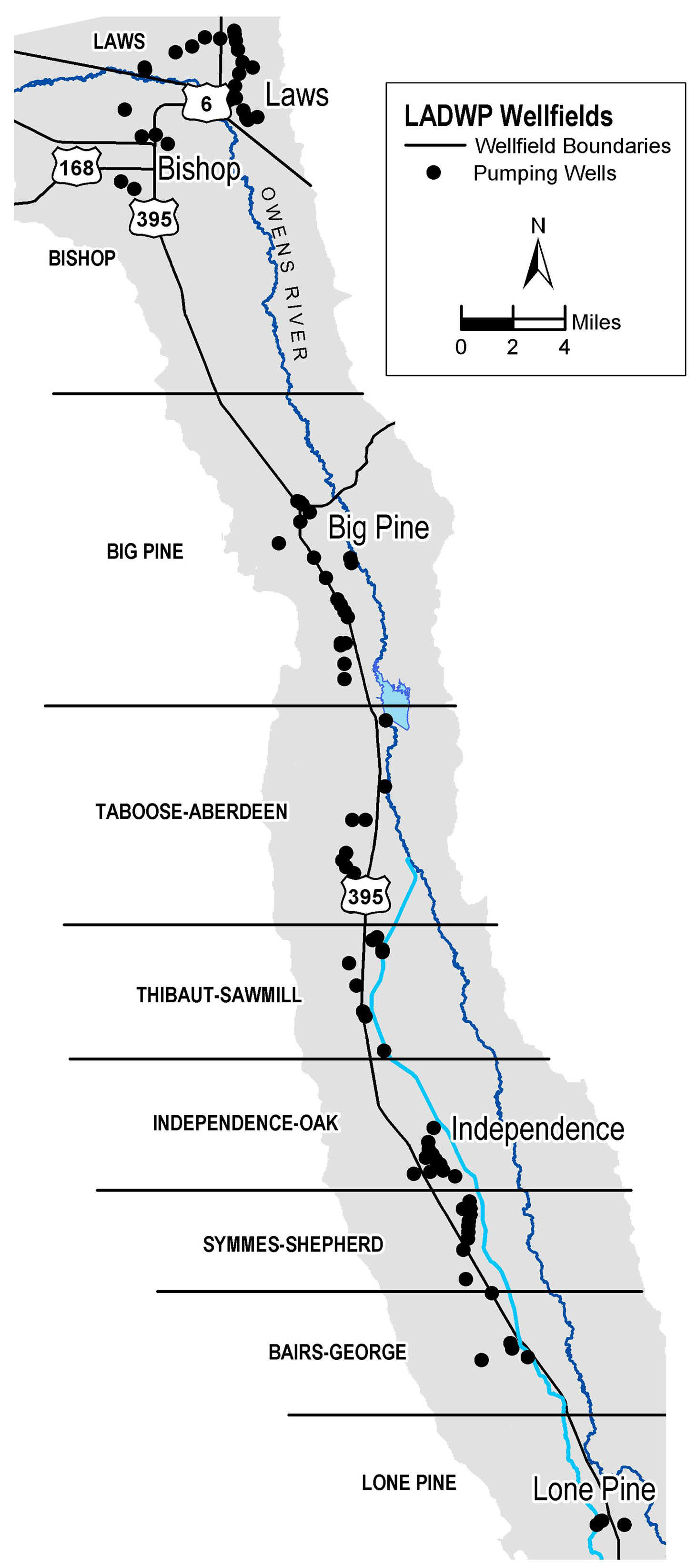
2002-2003 LADWP PumpingInyo County and LADWP agreed to a maximum groundwater pumping limit of 86,000 acre-feet for April 1, 2002 – March 31, 2003. Actual pumping for the period was 82,281. Table 2 shows planned and actual pumping for 2002-2003 by wellfield. Figure 1 on page 4 shows the Owens Valley wellfields and LADWP pumping from 1971 to 2002. Table 2. Owens Valley planned and actual groundwater pumping in acre-feet for runoff year 2002-2003. (Source: LADWP)
|
LADWP Pumping and Uses on the Bishop Cone
Each year, Inyo County Water Department and LADWP conduct an audit of LADWP’s groundwater extraction and water uses on Los Angeles land in the Bishop area – referred to as the “Bishop Cone.” The Inyo/Los Angeles Water Agreement requires that LADWP’s annual groundwater extraction not exceed the amount of water used on its Bishop Cone lands.
The Water Agreement defines water uses as the amount of water supplied to Los Angeles land on the Bishop Cone less any return flow to the Los Angeles Aqueduct. Uses include irrigation, stockwater, and recreation, as well as conveyance losses (i.e. water seepage from canals and ditches). Groundwater extraction is defined as the sum of all groundwater pumped by LADWP on the Bishop Cone plus the amount of artesian water flowing from uncapped wells.
LADWP collects the pumping and surface water information at mutually agreed upon measuring stations and provides that data to the county. The Water Department performs the audit and reports on the water uses and groundwater extractions on the Bishop Cone. Table 3 shows the results of Bishop Cone audits performed to date.
Table 3. Summary of Bishop Cone audits. (Source: ICWD)
|
Runoff Year |
Uses |
Extractions |
| 1995-1996 |
31,073 |
9,006 |
| 1996-1997 |
25,098 |
14,421 |
| 1997-1998 |
22,750 |
15,541 |
| 1998-1999 |
21,894 |
10,073 |
| 1999-2000 |
23,661 |
16,243 |
| 2000-2001 |
21,498 |
15,560 |
| 2001-2002 |
22,514 |
15,818 |
Owens Valley Water UsesWater uses on LADWP’s Owens Valley lands for the 2002-2003 runoff year were 84,851 acre-feet. These uses include irrigation, stockwater, recreation and wildlife, and enhancement/mitigation. Irrigation refers to water used to irrigate LADWP lands leased to ranchers. Stockwater is water released in ditches and canals for livestock and other water related uses on LADWP lands. Recreation and wildlife refers to LADWP water releases to areas such as Buckley and Rawson ponds west of Bishop and Farmers Pond north of Bishop. Enhancement/mitigation (E/M) refers to projects developed by Inyo County and LADWP to improve the value or attractiveness of an area or to mitigate effects of former LADWP pumping practices. The projects include Klondike Lake, Lone Pine Riparian Park, woodlots in Independence and Lone Pine, several pastures and alfalfa fields, and water releases to the Lower Owens River since 1986. Water supplied to Owens Valley fish hatcheries is not considered a water use, since this water flows through the hatcheries and into the Los Angeles Aqueduct. Table 4. Owens Valley uses in acre-feet for runoff years 1998-99 through 2002-03. (Source: LADWP)
|
LADWP Pumping by Wellfield 1971-2002
|
|
 |
|
||||||
Figure 1. General north/south boundaries of LADWP wellfields, and LADWP pumping by wellfield from 1971 to 2002.|
(Note that the scale for pumping varies by wellfield.)
groundwater from 1985-87 to 1992 (2a) and through 2002 (2b).
Gray and black circles show drop in groundwater of at least
2 and 4 feet, respectively. Open circles represent wells with
groundwater drop less than 2 feet. Wells with water in 1985-87
that were dry in 1992 (2a) and 2002 (2b) are marked with an “x.”
Numbers in parentheses are the number of wells in each category.
Groundwater Conditions
When LADWP inventoried Owens Valley vegetation between 1984 and 1987, water tables were generally high throughout the valley because of a series of wet years (1982-1986) and relatively low groundwater pumping. The vegetation mapped during that period, which became the baseline for management under the Inyo/Los Angeles Water Agreement, reflected these conditions.
Following the inventory, during the first three years of the 1987-1992 drought, LADWP pumped approximately 210,000 acre-feet (1987), 200,000 acre-feet (1988), and 155,000 acre-feet (1989). Water tables declined in most wellfields below the plant root zones, and as a result, the vegetation declined.
In 1990, in recognition of the decline in water tables and vegetation and the experimental nature of the management techniques of the Water Agreement, the Inyo/LA Standing Committee adopted a Drought Recovery Policy. The policy required that groundwater pumping be managed conservatively to allow substantial recovery of water tables, soil moisture, and vegetation. Since then, LADWP’s pumping has been lower than the pumping of the late 1980s (see page 4). In response to both lower pumping and several high runoff years, water tables rose during the 1990s, peaking in 1999. More recently, pumping and four years of below normal recharge have led to gradual water table declines. These declines have not been as severe as during the late 1980s because the Drought Recovery Policy held pumping to relatively low levels.
Figure 2a shows three categories of drawdown that occurred at 220 shallow monitoring wells between the average April depth to water in 1985-1987 and April 1992, the last of six consecutive dry years. Figure 2b shows the difference between April 1985-1987 water levels and April 2002 levels at 219 monitoring wells. The gray background shows the area within 1.5 miles of LADWP pumping wells.
The circles in Figure 2 are shaded according to how close the wells are to baseline levels. Areas of greatest water table decline in Figure 2a (black circles) coincide with the locations of highest groundwater extraction. In Figure 2b, many of the monitoring wells that are the furthest from recovery to 1985-1987 levels (black circles) are also near areas where the greatest amount of pumping has occurred. Comparison of Figures 2a and 2b shows that some monitoring wells have recovered in response to the high recharge and reduced pumping managed under the Drought Recovery Policy; however, many wells remain below baseline levels (black and gray circles).
Vegetation Conditions
–Sally Manning, Vegetation Scientist
During summer 2002, Inyo County Water Department once again directed a field inventory of vegetation conditions in 96 vegetation parcels throughout Owens Valley. Parcels were located in areas affected by pumping (wellfields) and areas not believed to have been directly affected by pumping during the 1987-1992 drought (controls).
Typically, the Water Department assesses Owens Valley conditions with regard to the Drought Recovery Policy (DRP) based on vegetation and water table data for the same year. However, as of press time, reliable estimates of 2002 depth to the water table for the 96 parcels were still being computed. Thus, for this analysis, the parcels were placed into one of four categories, based on 2002 vegetation data and April 2001 water table information. Readings in various monitoring wells throughout the valley showed some lowering of the water table from April 2001 to April 2002 in both wellfield and control areas. For the purposes of this summary, it is assumed that none of the changes were significant enough to result in a re-classification of parcels into different management categories with regard to the DRP.
The four DRP categories are:
Control: Parcel not directly affected by pumping during the 1987-1992 drought. In 2002, 30 of the 96 parcels were classified as controls.
DRP: Parcel experienced water table drawdown due to pumping during the drought, and since the drought, water levels have not returned to April 1985-87 average level or to the root zone and/or perennial cover has not returned to baseline (that is, the cover that was measured when the parcel was first inventoried during the mid-1980s). Therefore, the parcel is still subject to the DRP. Thirty-one of the 96 parcels inventoried in 2002 were placed in this category.
DRPfree: Parcel experienced water table drawdown due to pumping during the drought, but since the drought, the water table has recharged the root zone sufficient to promote perennial cover to meet or exceed baseline level. (Since that occurred, however, the water table may once again have dropped. The extent to which this occurred during 2002 is not currently known.) Thirty-two of the 96 parcels inventoried in 2002 were placed in this category.
More study: Three parcels east of Independence experienced high water table levels during the mid-1980s which subsequently dropped and have not returned. This water table fluctuation pattern may be due to water spreading in the Blackrock area during the mid-1980s, but it also may be due to pumping from the Independence exempt wells.
The 2002 growing season was preceded by very low precipitation amounts (see article on page 2). Therefore, environmental conditions for the 2002 growing season can be characterized as the fourth consecutive dry year with relatively small amounts of water table fluctuation.
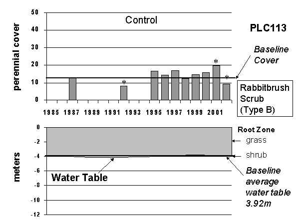
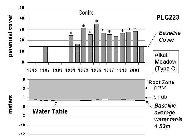
Overall in 2002, perennial cover declined throughout the valley relative to 2001 and relative to baseline. Average change relative to baseline for the Control parcels was -7.4%, but this value was not statistically significantly different from no change (Figure 3). So it can be concluded that, on average, perennial cover in Control parcels was similar to baseline levels. From 1991 through 1994, cover in the Control group was similar to baseline, and from 1995 through 2001, it was significantly greater than baseline. In 2002, perennial cover in the Control group returned to being similar to baseline. Thus over the twelve years the Water Department has monitored vegetation, Control perennial cover averaged at or above baseline (Figure 3).
| Vegetation Conditions – continued | |||||||||||||||||||||||||||||||||||||||||||||||||||||||||||||||||||||||||||||||||||||||||||||||||||||||||||||||||||||||||
| In contrast with the Control group, perennial cover was statistically significantly less than baseline for both wellfield groups (DRP and DRPfree) when averaged for all parcels (Figure 3). Average perennial cover has been statistically significantly less than baseline since 1999 for the DRP parcels and has been at or below baseline during all twelve years. For the first time since the DRPfree group was created (1996), perennial cover averaged statistically significantly below baseline (Figure 3). It remains to be seen if the suppressed cover will continue or whether the response for the DRPfree group is intermediate between that of the Control and DRP group. Water levels in some DRPfree parcels remained more or less constant between 2001 and 2002, but for others, water levels may have been lowered due to recent pumping. Splitting the DRPfree group into two or more groups that more appropriately depict management conditions may be warranted, but depends on acquisition of sound water table estimates. At the scale of the individual parcel, adequate depth to water table estimates exist for about half of the parcels inventoried in 2002. Examples of vegetation and water table conditions through time are provided in Figure 4. |
|||||||||||||||||||||||||||||||||||||||||||||||||||||||||||||||||||||||||||||||||||||||||||||||||||||||||||||||||||||||||
| Table 5. Change in perennial cover relative to baseline for Control, DRP, DRPfree and more study parcels, broken down by wellfield. For example, if a parcel’s baseline cover was 30% and its 2002 cover was 15%, the change relative to baseline would be -50.00. Bold entries show when a paired (dependent) t-test revealed a statistically significant difference at p <= 0.05 between baseline perennial cover and 2002. The standard error of the change value is presented as well as the number of parcels in each group. Values shown with shading are graphed in Figure 3. | |||||||||||||||||||||||||||||||||||||||||||||||||||||||||||||||||||||||||||||||||||||||||||||||||||||||||||||||||||||||||
|
 |
 |
|
 |
 |
|
 |
 |
|
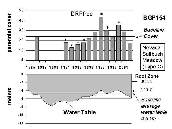
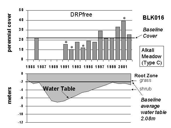
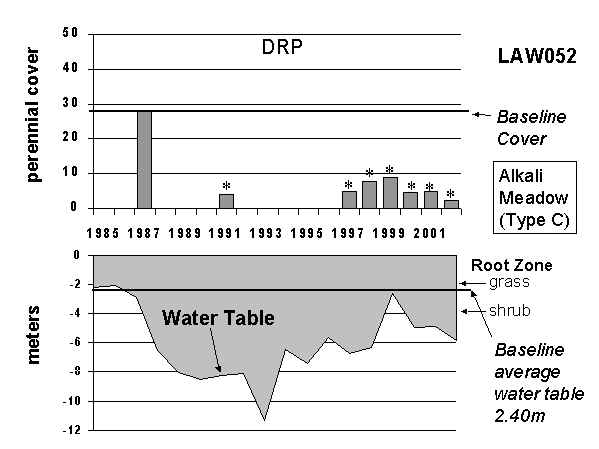
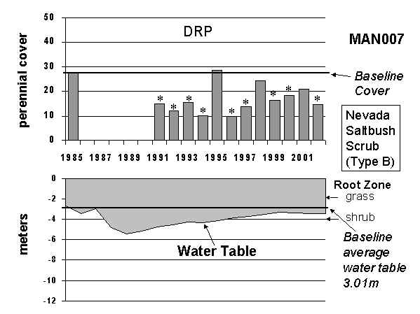
| Figure 4. Perennial cover and estimated distance to the water table from the mid-1980s baseline period through 2002 for two Control parcels, two DRPfree parcels, and two DRP parcels. Asterisks denote statistically significantly different cover from baseline (at p <= 0.05) using an independent t-test. A line is drawn indicating the mid-1980s (baseline) perennial cover. The distance to the water table is shown in meters relative to the ground surface (zero), and water table estimates are based on Dr. Robert Harrington’s “ordinary kriging.” The approximate bottom of the grass root zone is indicated at -2m and the shrub root zone at -4m. The average parcel water table estimate derived from April 1985, 1986, and 1987 estimates is shown as a line labeled “Baseline average water table,” and the estimated value is provided. Similar graphs for each inventoried parcel appeared in Manning’s 2002 report on vegetation conditions with regard to the Drought Recovery Policy (see Manning, S. J. 2002. Classification of re-inventoried vegetation parcels according to the Drought Recovery Policy, 2001. Inyo County Water Department report. Available at www.inyowater.org) | ||
Soil Water Conditions
— Aaron Steinwand, Soil Scientist
The Inyo/Los Angeles Water Agreement established procedures to determine which LADWP pumping wells can be operated based on soil water and vegetation measurements. Staff from the Water Department routinely monitors depth to groundwater and soil water content at 25 sites in wellfields and eight sites in control areas. Data from 22 wellfield sites visited each month are used to determine the operational status (On or Off) of nearby pumping wells. In October 2002, nine sites were in On-status. Three sites with low plant cover entered On-status following November storms and one site entered On-status in March due to water table recovery and precipitation.
The purpose for the On/Off procedures is to manage pumping to protect plant communities that require periodic connection to the water table for long-term survival. Generally, the sites with On-status have wet soil and shallow water tables, and the Off-status sites have dry soil and deep water tables. The On/Off determination is affected by several other factors, however, and sometimes On-status sites are those with a deep water table and low plant cover. Conversely, a site with adequate water table depth may be in Off-status if the water table occurs just below the root zone and plant cover is high. These inconsistencies contradict the assumption that operating pumps in On-status will not adversely affect vegetation near the monitoring sites, but operating wells in Off-status will.
We determine which monitoring sites are connected with the water table to give a clearer picture of the conditions underground that are affected by pumping. We rely on soil water and groundwater data because the water table depth necessary to provide water to the plant roots depends on the soil characteristics as well as water table depth. For example, the capillary rise above the water table in a silty soil is much greater than in a sandy soil. At the same water table depth, the plants may have access to groundwater if the soil is silty, but not if it is sandy. How well plant roots can take up groundwater also depends on the type of vegetation. In similar soils, a shallower water table is necessary to supply groundwater to grasses than shrubs because of the shallower roots of the grasses. For management purposes, grass-dominated monitoring sites are assigned a root zone of 2 meters; shrub sites are assigned a root zone of 4 meters.
The wellfield monitoring sites were grouped into three categories to summarize the connection between the root zone and the water table. Brief descriptions of the three categories are given below.
- Disconnected: No groundwater is recharging the root zone. Thirteen sites occur in this category. Sites L2, TA4, and IO1 have retained soil water in the root zone. Soil at the other sites is dry except at shallow depths affected by rain.
- Weakly connected: Water table fluctuations cause soil water changes in the bottom half of the root zone. Seven sites occur in this category, and all have a considerable amount of retained soil water.
- Connected: Water table fluctuations cause soil water changes in the top half of the root zone. Five sites occur in this category.
The relatively low pumping and high runoff from 1995 to 1998 caused the water table and soil water recovery to increase at most monitoring sites from the decline induced by drought and large amounts of pumping in the late 1980s. Since 1999, however, the water table stopped rising or began to decline at most sites because of lower runoff, increased pumping, or because water tables approached shallow depths similar to pre-drought levels. Consequently, the number of sites where soil water responds to water table fluctuations has decreased. As of April 2003, the water table was supplying water to the root zone at twelve monitoring sites located in wellfields (Figure 5). This compares to about 20 sites with groundwater in the root zone in 2000. Soil water at slightly more than half of the sites (13) did not increase at depth after plant transpiration ceased in the fall of 2002 and/or did not respond to water table increases over the following winter suggesting that the water table and root zone are disconnected.
Research Aims to Improve Management
Since 2000, Inyo County Water Department (ICWD) and LADWP have been investigating ways to improve the way LADWP manages water resources in the Owens Valley. Following are status reports on the studies being conducted by ICWD and LADWP. Copies of the study proposals and reports are available at ICWD and on the ICWD website at www.inyowater.org.
Development of Hydrological Modeling Tools
Robert Harrington, ICWD; Saeed Jorat, LADWP
Funded by LADWP and the California Department of Water Resources
This study is aimed at developing tools to evaluate the impact of groundwater pumping, climatic variations, surface water management, and other hydrologic changes on groundwater levels. The study addresses both statistical and numerical modeling tools. The statistical models have been updated, the error analysis and driving variables refined (Harrington, 2001), and the models have been extended to provide predictions at monitoring sites (Steinwand and Harrington, 2003a). These advances have enabled ICWD technical staff to evaluate “what-if” scenarios, such as how much water table recovery would have occurred without the groundwater pumping restrictions of the Drought Recovery Policy (Steinwand and Harrington, 2003b). The numerical modeling part of this study aims at developing the USGS groundwater model for the Owens Valley into a tool for use by ICWD and LADWP staff. Inyo County has hired Wes Danskin, the developer of the USGS model (Danskin, 1998), to conduct a post-audit of the model, where the model’s predictions for 1989 through 2002 are compared to what actually occurred. The model has been installed on ICWD and LADWP computer systems, data for the post-audit have been assembled, and the consultant is currently putting the data into the model. Additionally, data from the ET study (see below) have been used to develop refined coverages of ET for input into the numerical model. Estimated completion: March 2004.
Development of a Model for Predicting Phreatophyte Water Use and Soil Water Replenishment
Aaron Steinwand, Robert Harrington, ICWD
Funded by the Department of Water Resources
The purpose of this study is to combine information from vegetation, groundwater, precipitation, and soil water monitoring into a model to predict depletion and replenishment of stored soil water above a fluctuating water table. This capability will help protect Owens Valley vegetation by predicting how long soil water will support the vegetation after pumping commences. If soil water information will continue to be used to trigger pumping decisions, this type of model is needed to evaluate the environmental effects of proposed pumping scenarios and to provide reliable forecasts of expected pumping yields. The study is underway.
Evapotranspiration from Groundwater-Dependent Plant Communities: Comparison of Micrometeorological and Vegetation-Based Measurements
Robert Harrington, Aaron Steinwand, ICWD;
Paula Hubbard, David Martin, LADWP
Funded by LADWP and Department of Water Resources
Evapotranspiration (ET), the conversion of liquid water to vapor, plays a key role in both the management mechanisms implemented in the Inyo/Los Angeles Water Agreement and in the Owens Valley water budget. The purpose of this study is to measure ET using specialized weather stations and compare these measurements to the Water Agreement’s methods and the Kc method (Steinwand et al., 2001) of calculating plant-water requirements. Three years of ET, soil water, and plant cover measurements have been collected in various Owens Valley plant communities. At sites where vegetation is connected to the water table, measured ET agreed with Kc estimates. Multiple measurements of vegetation cover may be necessary to insure that the annual maximum plant cover is well-characterized (Steinwand et al., 2002). Results collected so far have been coupled with vegetation cover estimates derived from satellite imagery (Elmore et al., 2000) to generate improved coverages of ET for the regional groundwater model (Harrington and Steinwand, 2002). Estimated completion: April 2004.
Characterization of Confining Layer Hydrologic Conductivity and Storage Properties in the Owens Valley
Randy Jackson, ICWD; Saeed Jorat, LADWP
Funded by LADWP
The purpose of this study is to determine confining layer hydrologic properties to assist groundwater modeling efforts and to improve the management of wells sealed to the deep aquifer. Pumping from deep aquifers potentially could be managed differently than the Water Agreement methods. Without the information to be developed by this study, however, it is difficult to predict the magnitude and timing of water table drawdown from pumping deep aquifers. This complicates assessment of the effects of different pumping scenarios. The first phase of this study has been completed, including a sensitivity analysis and an analysis of available aquifer test data. In the future, ICWD and LADWP will improve the GIS maps developed under the first phase of the study, improve the characterization of the confining layer, perform deep-well operational tests, and improve procedures to manage groundwater pumping from the deep aquifer.
Shallow and Deep Groundwater Geochemistry and the Source of Spring and Seep Water in the Owens Valley
Aaron Steinwand, Randy Jackson, ICWD;
Saeed Jorat, LADWP
Funded by LADWP
One purpose of this study is to conduct an intensive sampling campaign at selected springs, monitoring wells, surface water, and pumping wells to determine the geochemical characteristics of the groundwater. The primary goal of the study is to better understand the source of groundwater emanating from the springs. Typically, deeper groundwater differs chemically from shallower groundwater. The linkage of spring water to either a shallow or deep source or some combination affects the potential for pumping to impact these areas. The study is being conducted by LADWP, ICWD, Montgomery Watson Harza (MWH), and Dr. Randy Bassett of Geochemical Technologies Corporation. The field sampling was conducted in March and April 2002, and samples were sent to MWH and University of Arizona laboratories for analysis. Most lab work was completed quickly, but some analyses required a few months to complete. Based on the preliminary results, the group decided to collect additional samples from a small number of wells in April 2003. Two of the wells were newly installed near one spring area in 2003. Completion of the final report is tentatively set for fall 2003.
Application of Canonical Community Ordination (CANOCO) to Assess Vegetation Change
Sally Manning, ICWD; David Martin, LADWP
This study will apply statistical techniques to an extensive dataset of vegetation measurements collected by ICWD vegetation staff to quantify the importance of several environmental factors, such as water table fluctuations, influencing vegetation changes observed in the last decade.
Since 2000, the principal investigators have worked independently, studying factors influencing vegetation change. Dr. Manning has since determined that it may be reasonable to use multiple linear regression as the analytical method. Results of preliminary evaluations have been produced for internal review and were presented by Dr. Manning at the 2002 meeting of the Ecological Society of America.
Inventory and Classification of Riparian Vegetation in the Owens Valley for Use in Future Monitoring
Sally Manning, ICWD; David Martin, LADWP
Funded by LADWP
The objective of this study is to inventory, map, and classify riparian (Type D) vegetation on Los Angeles-owned land in the Owens Valley to improve monitoring and management of these areas. This study was suggested in the Green Book (the technical appendix to the Water Agreement) but has not been completed. The Standing Committee agreed at its March 23, 2000, meeting that this work will be conducted by a consultant selected jointly by ICWD and LADWP, and the contract will be managed by LADWP. Work was to begin in March 2001. Currently, LADWP is reviewing a draft request for proposals and outlines of areas to be inventoried.
Development of a Demographic Model for Nevada saltbush (Atriplex torreyi)
Sally Manning, ICWD; David Martin, LADWP
The purpose of this study is to use existing data for Nevada saltbush collected by ICWD vegetation staff to develop a model that could allow researchers and managers to make predictions about future population trends of this species. Nevada saltbush is a native shrub that commonly invades meadows subjected to pumping. It has the potential to out-compete grass species and change the character of the plant community in a way not allowed under the Water Agreement. It is unclear whether, once begun, saltbush invasion can be halted and whether existing saltbush-dominated communities are sustainable.
Since 2000, the principal investigators have worked independently on this study. Dr. Manning continues to collect field data, and a preliminary report was recently completed.
Update on Memorandum of Understanding
The Memorandum of Understanding (MOU) is an agreement between California Department of Fish and Game, State Lands Commission, Sierra Club, Owens Valley Committee, Los Angeles Department of Water and Power, and Inyo County. The MOU addressed concerns raised by these organizations and state agencies over the Lower Owens River Project and other provisions of the 1991 environmental impact report (EIR) for groundwater management in the Owens Valley.
The MOU requires LADWP and Inyo County to implement numerous environmental projects and studies. Here is a summary of MOU projects and accomplishments since the MOU went into effect during 1997.
Lower Owens River Project
This project was originally a provision of the Inyo/Los Angeles Water Agreement; it was later identified in the 1991 EIR as compensatory mitigation for impacts from LADWP’s water exports that occurred between 1970 and 1990. The MOU augments the Water Agreement and the EIR. As augmented, the LORP consists of:
The Lower Owens River. A 60-mile stretch of river channel will be rewatered from the point where the river is diverted to the Los Angeles Aqueduct to Owens Lake. River flows will be approximately 40 cubic feet per second (cfs), with higher “seasonal habitat flows” up to 200 cfs.
The Owens River Delta Habitat Area. 6-9 cfs will be supplied to an area of wetlands at the north end of Owens Lake to provide habitat for shorebirds, waterfowl, and other animals.
Off-River Lakes and Ponds. Existing off-river lakes and ponds in the LORP area will be maintained for fisheries, waterfowl, shorebirds, and other animals.
The 1,500-Acre Blackrock Waterfowl Habitat Area. In average and above runoff years, approximately 500 acres within an overall project area of 1,500 acres will be flooded to provide habitat for resident and migratory waterfowl and other native species. In drier years, a smaller area will be flooded.
Status: Under the MOU, the four components of the LORP must be implemented no later than June 13, 2003. However, the project was not implemented by the MOU deadline. (See article on page 1.)
With the assistance of Congressman Jerry Lewis, Inyo County has obtained approximately $6 million from the federal government to offset the costs of implementing the project. Inyo County will continue to seek federal funds to assist it in meeting its share of the substantial long-term operation costs for the project.
Yellow-Billed Cuckoo Habitat Evaluation
Under the direction of LADWP and Inyo County, Ecosystem Sciences, Inc. (ESI), will evaluate Yellow-billed Cuckoo habitat in woodland areas of Hogback and Baker creeks. ESI will develop habitat enhancement plans for these areas in consultation with LADWP, the lessees for the areas, and the MOU parties. The MOU requires the evaluations be completed by June 2000. However, the MOU parties agreed to extend that deadline to November 2000, then to September 2001.
Status: ESI submitted two draft habitat enhancement plans to the MOU parties in September and October 2000. The Water Department and Owens Valley Committee commented on the draft plans in May 2001. ESI is to revise its draft plans for a second MOU party review. ESI has not announced when the draft plans will be released.
Inventories of Plants and Animals at Springs and Seeps
LADWP and Inyo County must complete an inventory of plants and animals at springs and seeps on Los Angeles land in the Owens Valley. The MOU required that the inventories be completed by June 2000. The MOU parties extended that deadline to December 2000 then to July 2001.
Status: ESI submitted results of its inventory to the MOU parties in June 2001. In December 2002, the Water Department submitted comments to concerning the inventory. ESI has not announced when it will respond to the Water Department’s comments.
Additional Mitigation
Under the direction of LADWP and Inyo County, ESI will recommend on-site and/or off-site mitigation measures and a mitigation plan for Hines Spring, to supplement mitigation measures identified in the 1991 EIR for impacts to Owens Valley springs. LADWP is to provide 1,600 acre-feet of water per year to supply the recommended measures. The mitigation measures will be implemented by LADWP and maintained by LADWP and/or Inyo County. The MOU provided that plans for the mitigation measures would be completed by June 2000. However, the MOU parties agreed to extend that deadline first to November 2000, then to September 2001.
Status: ESI prepared drafts of the mitigation plans in September and December 2000. The Water Department commented on the draft plans in May 2001. ESI is to prepare revised draft plans for review by the MOU parties. ESI has not announced when the drafts will be released.
Owens Valley Land Management Plans
LADWP, in consultation with the MOU parties and others, is to develop land management plans for their Owens Valley land. Priority will be given to riparian areas, irrigated meadows, and sensitive plant and animal habitats. The plans will provide for the continuation of sustainable uses, including recreation, livestock grazing, agriculture, and other activities and will consider the enhancement of threatened and endangered species habitats. The planning effort is to begin by 2002, and plans are to be completed no later than 2007. Each plan will contain an implementation schedule and will be implemented in compliance with CEQA.
Status: ESI has completed draft land management plans for Los Angeles land within the LORP area.
Type E Vegetation Inventory
By December 1999, LADWP and Inyo County were to inventory vegetation identified in the Inyo/Los Angeles Water Agreement as “Type E,” or irrigated. The data from the inventory will be used as the baseline conditions for management of vegetation under the Water Agreement.
Status: The inventory was completed in 1999.
Aerial Photo Analysis
The MOU provides that LADWP, Inyo County, and experts in the field of aerial photography will (1) evaluate the merits of using air photos to monitor Owens Valley vegetation, (2) determine if air photos could be used to refine the 1984-1987 vegetation map, and (3) develop recommendations for using air photos and other remote sensing techniques to monitor vegetation in the future. If cost-effective relative to other monitoring techniques, LADWP and the County are to institute the recommendations. The MOU parties extended the deadline for completing the analysis from June 2000 to December 2000.
Status: As of January 2002, a consultant working under the direction of LADWP and the Water Department completed reports addressing the three MOU requirements described above.
Mitigation Plans for Impacts Identified in the EIR
The 1991 EIR identifies approximately 1,300 acres in the Owens Valley that were adversely affected by LADWP water gathering. The EIR provides that this land will be revegetated with plant species native to the valley. By June 1998, the Technical Group was to complete mitigation plans for the areas.
Status: In August 1999, following receipt of comments from the MOU parties, the Inyo/Los Angeles Technical Group approved the mitigation plans. In January 2002, the Water Department notified LADWP that plans for four on-site mitigation measures had been omitted from the mitigation plans and recommended that plans be developed for these measures and incorporated into the overall mitigation plans. The Water Department submitted draft plans for the measures to LADWP in March 2003. See page 16 for the status of the mitigation identified in the EIR.
Status of Inyo/Los Angeles Water Agreement
In June 1997, the Inyo/Los Angeles Water Agreement went into full effect. Although Inyo County and LADWP had instituted the groundwater management provisions of the Agreement in 1989, many of the Agreement’s provisions remained to be implemented. The following is a report on the status of the Water Agreement’s commitments.
| Groundwater Management: Inyo County and LADWP are to manage water resources within the County to avoid certain described decreases and changes in vegetation and to cause no significant effect on the environment which cannot be acceptably mitigated while providing a reliable supply of water for export to Los Angeles and for use in Inyo County. | By agreement of the Inyo/Los Angeles Standing Committee, implementation of groundwater management pursuant to the Agreement commenced in the fall of 1989. |
| New Wells & Production Capacity: LADWP may replace existing wells and construct new wells in areas where hydrogeologic conditions are favorable and where operation of such wells will not cause a change in vegetation that would be inconsistent with the agreement. The agreement and EIR describe 15 new wells that LADWP proposes to construct in the Owens Valley. | LADWP has constructed one of the 15 wells allowed under the Water Agreement in Lone Pine. The Technical Group must establish management for the well before it can be operated. There is no schedule for construction of the 14 new wells described in the EIR. LADWP constructed a new well to replace the town water supply well in Big Pine. |
| Cooperative Studies: LADWP may provide funding for the costs of conducting studies related to the effects of groundwater pumping on the environment of the Owens Valley. | Several studies approved by the Standing Committee are underway. See report on pages 11-12 for details concerning these studies. |
| Groundwater Pumping on the Bishop Cone: Before LADWP may increase groundwater pumping on the Bishop Cone, or construct new wells on the Cone, Inyo and LADWP are to develop an audit procedure for determining the exact amount of water annually used on LA-owned land on the Cone. LADWP pumping on the Cone must be in strict adherence to the provisions of the “Hillside Decree.” | The Standing Committee adopted a Bishop Cone audit procedure, and the audit has been performed by ICWD since 1996. Other than replacement wells, there is no schedule for constructing new wells or increasing groundwater pumping on the Bishop Cone. In 1998, a Superior Court judge entered a “Memorandum of Judgment” in Matlick v City of Los Angeles. |
| Groundwater Recharge Facilities: LADWP may construct groundwater banking and groundwater recharge facilities in the County. The 1991 EIR describes certain groundwater recharge facilities in Laws and Big Pine, which may be constructed. | LADWP has not proposed constructing the groundwater recharge facilities in Laws and Big Pine described in the EIR. |
| Enhancement/Mitigation Projects: All existing E/M projects will be maintained, unless the County and LADWP agree to modify or discontinue them. New projects may be implemented by the agencies. The agreement provides that E/M projects will be supplied by designated E/M wells unless otherwise agreed. Special considerations apply to E/M projects identified as mitigation in the 1991 EIR. | All E/M projects that have been implemented are being maintained. See page 16 for the status of E/M projects identified as mitigation. |
| Lower Owens River: See report on page 13. | See report on page 13. |
| Town Water Systems: LADWP will transfer to Inyo County, or another Owens Valley public entity or entities, ownership of the water systems in the communities of Lone Pine, Independence, and Laws. Prior to transferring the systems, evaluations of each system will be performed by a mutually agreed upon consultant, and if necessary, work will be done to upgrade the systems. LADWP will provide free water, up to specified amounts for each town. | The County contracted with a private company to assume the operation, maintenance and billing for the systems in July 1999. Pursuant to an agreement with LADWP, the County completed upgrades of the systems in December 2002, using funds provided by LADWP. LADWP will transfer ownership of the systems to the County once a transfer agreement between the agencies is completed. |
| Salt Cedar Control: LADWP is to provide funding to Inyo County to implement a saltcedar control program: $750,000 during the first three years of the program; thereafter, $50,000 per year adjusted upward or downward in accordance with the consumers price index. | Inyo County initiated the saltcedar control program in 1997. Saltcedar populations have been cut, treated and mapped from north of Bishop to south of Independence. During the past few years, the program focused its efforts on the Lower Owens River. See page 1. In 2002, LADWP paid the County $53,406 for saltcedar control. |
| Park Rehabilitation, Development, & Maintenance: LADWP is to provide up to $2 million to Inyo County to rehabilitate existing County parks and campgrounds and to develop new recreational facilities. LADWP is to make an annual payment of $100,000 (adjusted upward or downward in accordance with the consumers price index) to the County to maintain existing and new recreational facilities. | At Inyo County’s request, LADWP has provided $1,087,914 for park improvement projects. Los Angeles has also provided the annual payment to the County for parks operation and maintenance. The County has developed a plan and schedule for the park improvement projects. In 2002, LADWP paid the County $114, 009 for park maintenance. |
| Owens River Recreational Use Plan: As part of the parks rehabilitation program, Inyo may develop a plan for recreational use and management of the Owens River from Pleasant Valley Reservoir to the Owens River delta. | Recreation in the Lower Owens River Project area will be addressed in the project EIS/EIR. The County does not currently plan to develop a recreation plan for the river from Pleasant Valley to the aqueduct intake. |
| General Financial Assistance to the County: LADWP is to make an annual payment to Inyo to assist the County in providing services to its citizens. The annual payment is to be adjusted upward or downward each year in accordance with a formula in the State Constitution for a assessment of Los Angeles-owned property in Inyo County. | Los Angeles has provided the annual payment to the County, and made a payment of $1,795,637 in July 2002. Funds provided by Los Angeles have been deposited into the County General Fund and expended on County services as directed by the Board of Supervisors. |
| Financial Assistance for Water Related Activities: LADWP is to make an annual payment to Inyo to assist the County in providing water and environmentally related services to its citizens. The annual payment is to be adjusted upward or downward each year in accordance with the consumers price index. | Los Angeles has provided the annual payment to the County, and made a payment of $1,062,697 in July 2002. Funds provided by Los Angeles have been expended to fund the Inyo County Water Department. |
| Big Pine Ditch System: LADWP is to provide up to $100,000 for reconstruction and upgrading of the Big Pine ditch system. LADWP is to supply up to 6 cfs to the ditch system from a new well to be constructed west of Big Pine. | Procedures and guidelines for implementing the project were approved by the Standing Committee in 1998. LADWP released a mitigated negative declaration addressing the project and modifications to the Klondike Lake E/M project on June 5, 2003. |
| Park & Environmental Assistance to City of Bishop: LADWP is to make an annual payment to the City of Bishop to assist the City in maintaining its park and for other environment-related activities. The payment of $125,000 is to be adjusted upward or downward each year in accordance with the consumers’ price index. | Los Angeles has provided the annual payment to the City of Bishop. |
| Release of City Owned Lands: LADWP is to sell 26 acres of surplus LA-owned land within the Bishop city limits and release 75 acres of LA-owned land for public or private development. | LADWP has sold the 26 acres within Bishop. The Board of Supervisors approved selected parcels in Owens Valley towns and County staff is working with LADWP to set a schedule for the phased release of these lands. |
| Additional Sales of City-owned Lands: LADWP will negotiate in good faith for the sale of additional surplus Los Angeles-owned land in or near valley towns for specific identified needs. Any such sales are to occur subsequent to those described above. | LADWP periodically examines its land inventories to determine additional properties to be sold at auction as surplus. |
| Lands for Public Purposes: Los Angeles will negotiate in good faith for the sale or lease of any Los Angeles-owned land for use as a public park or for other public purposes. | LADWP and the County successfully transferred ownership of the Lone Pine Film Musuem. LADWP has agreed to lease additional land to the County for the Dehy Park expansion project in Independence. The lease area will be expanded from 1.3 acres to about 4 acres. |
| Withdrawn Lands: Inyo will support passage of withdrawn land legislation pertaining to federally owned lands in the County. | There is no withdrawn land legislation pending. |
| Legislative Coordination: Except under certain circumstances, Inyo and LA are to refrain from seeking or supporting any legislation, administrative regulation, or litigation that would weaken or strengthen local or state authority to regulate groundwater or that would affect any provision of the agreement. | The legislative coordination policy has been followed by the County and the City of Los Angeles. |
Inyo County’s Review of LADWP MitigationIn its 1991 environmental impact report, LADWP identified numerous areas in the Owens Valley that were adversely affected by groundwater pumping or other activities from 1970 to 1990. The EIR commits LADWP to mitigate these impacts by establishing pasturelands, supplying water to create wildlife habitats, and planting native vegetation. The following is a brief review of the status of these mitigation measures by the Inyo County Water Department (ICWD).
|